United Group Insurance

Flood warnings for the Missouri River extended until Wednesday

News

June 30th, 2024 by Ric Hanson

(COUNCIL BLUFFS, Iowa) – Flood warnings for counties located the Missouri River in Iowa and Nebraska have been extended now, until Wednesday. Minor to moderate flooding is expected to continue. Originally, the Missouri River was expected to have crested late Saturday in the Omaha area. The National Weather Service Sunday, said while all sites are expected to crest by early next week, repeated rounds of rain could lead to river levels remaining elevated for longer than currently forecast.

Emergency management officials say around half a dozen homes in the immediate Honey Creek area have been flooded, and so have around a dozen properties in the Goosehaven area—although most of those are not permanent homes.

At this time, EMA Director Doug Reed said there’s no indication when residents will be able to get back to their homes because the forecast keeps changing for when the river crests. After that, they’ll have to wait for the water to drain out, and then assess the damage to roads.

2 injured in a northern IA crash Saturday night

News

June 30th, 2024 by Ric Hanson

(Eagle Grove, Iowa) – A single-vehicle accident Saturday night in northern Iowa’s Wright County resulted in two people being transported to the hospital  with serious injuries. According to the Iowa State Patrol, a 2014 Toyota Camry driven by 19-year-old Yefri Anthony Lopez, of Clarion, was traveling north on Wright County Road R-33 at around 8:35-p.m., when the car veered off the road and into the east ditch.

The vehicle rolled over and came to rest on the driver’s side. Lopez was ejected during the rollover. He was not wearing a seat belt. His passenger, 25-year-old Joel Cifuentes, of Clarion, was trapped in the passenger seat of the vehicle. Both men were transported to separate hospitals for treatment.

Skyscan Forecast for Atlantic & the Nishna Valley: Sunday, June 30, 2024

Weather

June 30th, 2024 by Ric Hanson

Today: Sunny, with a high near 75. North northeast wind 5 to 10 mph becoming east southeast this afternoon.
Tonight: Partly cloudy, with a low around 59. East southeast wind 5 to 10 mph.
Monday: A chance of showers and thunderstorms. High near 73. SE winds 15-30 mph.
Tuesday: A chance of showers & thunderstorms. High near 87. S/SW winds 10-25 mph.
Wednesday: Partly sunny, with a high near 86.
Independence Day: P/Sunny w/a 50% chance of showers and thunderstorms. High near 85.

Saturday’s High temperature in Atlantic was 80. Our Low this morning, 55. Last year on this date, the High in Atlantic was 84, and the Low was 66. The All-time Record High in Atlantic on June 30th was 101 in 1933. The Record Low was 43, in 1940. Sunrise was at 5:49-a.m. Sunset today is at 8:58-p.m.

Brown Punches Ticket to Paris Olympics

Sports

June 29th, 2024 by Asa Lucas

EUGENE, Ore. – Former Hawkeye Brittany Brown qualified for the Paris Olympics with a 21.90 personal record in the 200 meters on Saturday night at Hayward Field.

Brown started in lane nine and finished second overall. Lanes seven, eight and nine produced the qualifiers, with Gabby Thomas (21.81) winning from lane seven. McKenzie Long earned bronze with a 21.91 from lane seven.

Brown is Iowa’s 26th Olympian and first since Kineke Alexander, Troy Doris and Diane Nukuri-Johnson qualified for the 2016 Games in Rio de Janeiro, Brazil.

The 2024 Paris Olympics begin on July 26.

Senior Paige Magee concluded her run at the U.S. Olympic Trials with a 15.57 in the semifinals of the 100-meter hurdles.

Magee ends her season as a second-team All-American in the 60-meter hurdles and the 100-meter hurdles. She is also Iowa’s school-record holder in both events.

HEAR FROM DIRECTOR OF TRACK AND FIELD JOEY WOODY:
“We are all so proud of Brittany and everything she has overcome to make her first Olympic team! She had her PR performance at the perfect time to punch her ticket to Paris and we are so excited for her. Tonight wasn’t Paige’s best performance, but this weekend doesn’t take away from the tremendous season she had. The 12.88 at the NCAA Championships and school record to finish as a second-team All-American were spectacular accomplishments. She has had an amazing career and thankfully, she’s coming back for her last indoor season next year, where she has some unfinished business.”

UP NEXT: The Olympic Trials conclude Sunday in Eugene with James Carter Jr. in the triple jump finals at 5:55 p.m. (CT). Austin Kresley competes in the 200 meters at the Mexico Olympic Trials tomorrow morning.

HAWKEYE RESULTS

Paige Magee (100-Meter Hurdles)

Semifinals

  1. 15.57

Brittany Brown (200 Meters)

Semifinals

  1. 21.90, PR, Q

SUNDAY’S SCHEDULE

Austin Kresley (200 Meters)

Mexico Olympic Trials

James Carter Jr. (Triple Jump)

Finals (5:55 p.m.)

Motorcycle accident Saturday evening in Atlantic

News

June 29th, 2024 by Ric Hanson

Cass EMS, Atlantic Rescue and Law Enforcement were called to the scene of a motorcycle accident this (Saturday) evening, on Atlantic’s north side. The accident was reported at around 6:37-p.m. It occurred in the Schildberg Campground area near the playground.

A female was said to have suffered a head injury. She was transported to Cass Health (CCMH). Additional information is currently not available.

Storm/tornado report from June 28, 2024

Weather

June 29th, 2024 by Ric Hanson

The National Weather Service in Des Moines, compiled a list of tornado events in Cass County, Iowa, for the evening of Friday, June 28, 2024:

9:00 PM Storm chase reports a funnel Cloud 5 miles SSW of Anita; Brief funnel cloud but structure becoming more ragged with time.

8:46 PM Storm chaser reports a brief tornado spun-up 2 miles SW of Wiota.

7:58 PM Law enforcement reports a tornado 3 miles W of Atlantic; Another small rope tornado south of Marne.

7:49 PM Storm chaser report a tornado 4 miles SSW of Marne; Rope tornado reported west of Atlantic.

Skyscan Forecast for Atlantic & the Nishna Valley: Saturday, June 29, 2024

Weather

June 29th, 2024 by Ric Hanson

Today: A slight chance of showers & thunderstorms this morning, otherwise mostly sunny & breezy. High near 80. N/NW winds 10-20 mph.
Tonight: Mostly clear, with a low around 53. N/NW winds 10-20 mph.
Tomorrow: Sunny, with a high near 75. East northeast wind around 10 mph.
Tom. Night: Partly cloudy w/a 20% chance of showers after midnight. Low around 58.
Monday: Mostly cloudy & windy, w/a 50% chance of showers and thunderstorms. High near 75.
Monday Night: A 60% chance of showers and thunderstorms. Breezy. Low around 68.
Tuesday: Partly sunny w/a 50% chance of showers and thunderstorms. High near 89.

Friday’s High in Atlantic was 86. The Low was 691. Rainfall in Atlantic at KJAN, amounted to .38″. This day last year in Atlantic the high was 90 and the low 65. The Record High in Atlantic on June 29th, was 102 in 1934. The Record Low was 46, in 1950. Sunrise today: 5:48 am. Sunset: 8:58 pm.

High School Softball Scores from Friday

Sports

June 28th, 2024 by Asa Lucas

Hawkeye Ten 

#7 West Monona 11, Harlan 0
Atlantic 9, Lewis Central 4
St. Albert 4, Glenwood 0

Western Iowa Conference

AHSTW 14, Fremont-Mills 0

Rolling Valley Conference 

Ar-We-Va 8, Glidden-Ralston 3
CAM 12, Boyer Valley 8
Woodbine 4, Coon Rapids-Bayard 0

Corner Conference 

Lenox 11, East Mills 1

Raccoon River Conference

#1 North Polk 5, Dowling Catholic 1
#12 Urbandale 7, Ballard 0
#6 Ankeny 7, Ballard 0
#15 Gilbert 8, Nevada 2
ADM 6, Johnston 1
ADM 8, Des Moines Roosevelt 0

Pride of Iowa Conference 

Lenox 11, Central Decatur 2
Nodaway Valley 6, Orient-Macksburg 3

West Central Activities Conference 

#1 Martensdale-St Marys 3, #10 Interstate-35 1

High School Baseball Scores from Friday

Sports

June 28th, 2024 by Asa Lucas

Hawkeye Ten 

Kuemper Catholic 12, Atlantic 4
Sioux City North 5, Lewis Central 4
Underwood 5, Harlan 0
Kuemper Catholic 5, Carroll 4

Western Iowa Conference

Riverside 18, Westwood 3

Rolling Valley Conference 

Ar-We-Va 4, Glidden-Ralston 2

Raccoon River Conference

Johnston 6, Boone 5
Winterset 14, Perry 0

Weak tornadoes form near Atlantic, Marne & other towns in Cass County; No early reports of damage

News, Weather

June 28th, 2024 by Ric Hanson

(Atlantic, Iowa) – Many people were caught off-guard this (Friday) evening, when the tornado siren blew in Atlantic. There was no prior warning from the National Weather Service. Instead, Cass County Emergency Management Coordinator Mike Kennon said he too, was surprised when he received word from Marne Fire Chief Josh Krause, that he had observed a funnel cloud south of Marne, west of Atlantic.

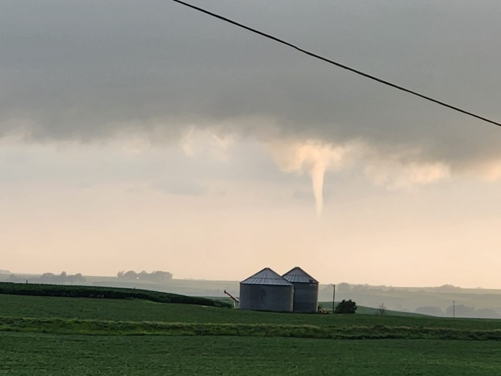
Photo courtesy Jeremiah Bruning, of Atlantic, taken just west of Atlantic on June 28th

The sirens in Marne and Atlantic were set-off a little before 8-p.m. Kennon said he saw a lot of rotation in the clouds, a rope tornado that primarily maintained its form as a funnel cloud, but others saw the twister connect with the ground. Its movement was very slow, Kennon said.  The first warning from the National Weather Service was issued at 7:55-p.m.

“That was only the beginning,” he said. “Lewis had a lot of rotation in the clouds, so we set-off the sirens.” There were also reports of a funnel east of Atlantic. “A lot of people were watching it closely,” Kennon said, as “We were really prepared for setting those sirens off again if something came down.”

The sirens were then set-off for the communities of Wiota and Anita. Kennon said he stopped in Wiota. “I believe everybody in town was out watching the rotation as it spun on the south side of town.” He reported there  was also a funnel cloud or two by Lake Anita.

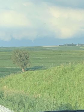
Funnel cloud taken from West 29th Street at 8:01 p.m. Friday night SW of Atlantic (courtesy Brett Altman)

Another Tornado Warning was issued for NE Cass County and NW Adair County, at 8:47-p.m.  There have been no reports of damage, as the weak tornadoes were mainly in the rural areas. Kennon said “There were a lot of people in their yards and a lot of people out, parked along the edge of the roads,” looking for rotation, and tornadoes on the ground. “With the sunset the way it was, you could really see what was going on, for sure.” Kennon says unless you are a trained storm spotter, being outside in the storm is “Not something I would recommend.”

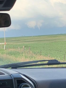
Photos courtesy of Zach Ploen & Evie Scott, west of Anita at around 9:30-p.m. Friday

One of the questions KJAN was asked on our Facebook page, was why there was no “All Clear” siren given after the danger appeared to have passed. He said “It’s been some time since we’ve had an All-Clear. The reason for that was…in general, people don’t know what the “All-Clear” means. It’s just a siren that’s going off, so they take it as another warning of some kind.” He recommends have a way to receive emergency messages, whether it’s by radio, NOAA Weather Radio or phone app, so that you can get information and know when it is safe to get out of your shelter. (Sign-up HERE for emergency alerts on your cell phone, in Cass County).

Mike Kennon reminds area residents tornadoes can form any time of the year, including during the month of December, as was the case on December 15, 2021, when 63 tornadoes touched down that day, making it the biggest single-day tornado outbreak in Iowa’s recorded history, according to the Weather Service. His advice: “Be weather aware.”