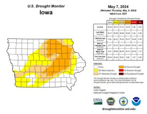
(Radio Iowa) – The latest U-S Drought Monitor map of Iowa shows no red areas indicating extreme drought.
DNR Hydrologist Tim Hall says we’ve been seeing red for a long time. “The first time in almost two years that we’ve not had extreme drought somewhere in the state of Iowa,” Hall says. It is a big turnaround, but not all the color has washed out of the drought map. “We still have half the state are so impacted by drought conditions, but that area is shrinking all the time as we get these good rains,” he says.
Hall has continually said we need weekly rains every month to turn things around, and that’s the pattern we’re now in. “We’ve now had five out of the last seven months have had above normal precipitation and that’s exactly the recipe we wanted,” he says, “where you get month over month just above normal precipitation, and that’s what’s really helping us to get out of the drought,” Hall says.
He says depth of the drought is evident in the lack of any major flood issues. “Go back to this winter when we had all that snow in January that melted very quickly and we had no flooding. And we’ve now had a couple of above normal precipitation months, and yes, we got some flooding, but nothing even approaching a widespread or catastrophic flooding,” Hall Says. “So that really points to a couple of things, how dry the soil was, and the fact that the rain we have received has been fairly well spaced out.”
Half of the state’s annual rainfall usually comes in May through August, and Hall says if we are above normal in any of those months, we could go a long way toward pushing all the drought colors off the map.


