

- KJAN, Atlantic .43″
- Exira 1.35″
- Elk Horn .52″
- Massena .4″
- Neola .77″
- Missouri Valley .58″
- Shenandoah .72″

(Greenfield, Iowa) – If anyone is wondering how to help the residents of Greenfield by donating cash or supplies, please see the St. John’s Catholic Church Facebook page, as that is a GREAT resource of information. The link is pinned to the kjan.com Facebook page.
An updated needs list (as of late Thursday) to help loca residents, include: Casey’s gas cards, Fareway gift cards, Dollar General gift cards (those stores we have here locally). Many residents lost everything, and many have lost power.
St. John’s officials say tarps are not currently needed, as they have an ample supply now. Plywood is also not needed, because there is a good supply on-hand. Clothing was collected at the Adair County Health and Fitness Center, and St. John’s says as of Thursday, they had enough clothing. Residents in Greenfield in need of clothing are invited to come in and shop. Friday’s hours are 8-a.m. To 6-p.m.
Grief and Trauma Counseling will be in Greenfield over the next few days.
If you’d like to make an online donation, please use the Greater Greenfield Community Foundation‘s paypal link: https://www.paypal.com/donate/…
This is the official way to give online! Designate ‘Tornado Relief’.
(Area) – Severe storms that formed in Nebraska early this (Friday) morning raced into western Iowa, causing the National Weather Service to issue Tornado Warnings for some areas (including in Cass County), where radar detected rotation in the atmosphere. The storms reached Atlantic at around 3:30-a.m., bringing heavy rain and damaging winds that caused some large tree limbs to fall and block the road, at 7th and Linn, and other locations. Downed tree limbs were also reported to have blocked some roads in Red Oak.
A complete list of storm events/timing/damage (if any), can be found under the Storm Reports story on the Weather page at KJAN.com. Winds were the primary factor in the damage that occurred, with sustained gusts estimated at anywhere from 60-miles per hour in Glenwood, to 75-miles per hour in Greenfield, where they are trying to recover from Tuesday’s deadly EF-4 tornado.
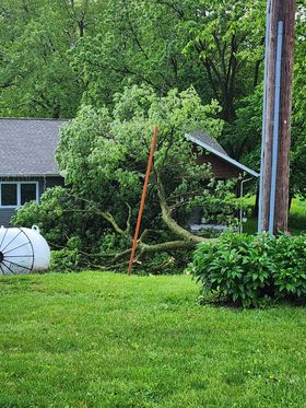
North of Glenwood. Photo courtesy Shannon Kennedy Barton.
The Weather service reports:
There were no immediate reports of injuries associated with this latest round of severe weather.
(Radio Iowa) – Continued rains across the state brought more improvement in the latest U-S Drought Monitor for Iowa. D-N-R Hydrologist Tim Hall says the two most severe categories of drought are no longer found on the map. “So we’re just down to just over 20 percent of the state is rated in the D-1 moderate drought, so we don’t have any severe drought, no extreme drought in the state anymore,” Hall says. Nearly 67 percent of the state now has no form of drought, which compares to only three percent with no drought in January. Hall says the northeast part of the state is still the driest area, but it’s a lot better now.
“Tama and Benton counties, the last three years, it’s been the driest three years on record for those particular counties in the state,” Hall says. ” And that’s even drier than the dustbowl years of the 30s or the drought of the 1950s. So they were very much in a whole drought wise, and it’s just going to take those parts of the state longer to recover.” Hall says his discussion with the state climatologist indicates we could see spring flip from record dry to record wet conditions this year. “We could very well see a top ten wettest spring season on record by the time all is said and done with here,” he says. The plentiful rain has had some farmers worried about finishing planting, and at times it leaves ponds of water in fields.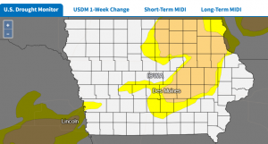
Hall says he’s not worried about that at this point. “The fields in the areas that routinely run into inundation problems are seeing that right now with the rain we’ve had, but I don’t think it’s a widespread or catastrophic problem around the state,” Hall says. “I think we’d become used to the dry conditions over the last four years, and we just have gotten out of the habit of seeing saturated fields and standing water.”
Hall says it’s good to see the groundwater and stream flows come back to normal for the first time in a long time. And he says June is normally the wettest month of the year, so the pattern is likely to continue.
Time of event  Type of event   Location       Latitude & Longitude
Date of event  remarks         source
0416 AM     Tstm Wnd Gst     Greenfield              41.30N 94.45W
05/24/2024  E75 MPH          Adair              IA   Emergency Mngr
            70 to 75 mph gusts along with dime-sized
            hail.
0400 AM Tstm Wnd Gst 2 S Willey 41.95N 94.82W
05/24/2024 M63 MPH Carroll IA Public

0339 AM Tstm Wnd Gst Audubon 41.72N 94.93W 05/24/2024 M62 MPH Audubon IA Public
0345 AM     Tstm Wnd Gst     8 SW Cumberland         41.19N 94.98W
05/24/2024  M61 MPH          Cass               IA   Public

0337 AM     Tstm Wnd Gst     Villisca                40.93N 94.98W
05/24/2024  M67 MPH          Montgomery         IA   Public

0330 AM     Tstm Wnd Dmg     Elliott                 41.15N 95.16W
05/24/2024                   Montgomery         IA   Emergency Mngr
            Emergency Manager reported the city of
            Elliot has lost power.
0326 AM     Tstm Wnd Gst     2 W Elliott             41.14N 95.20W
05/24/2024  M58 MPH          Montgomery         IA   Public
0321 AM Tstm Wnd Gst 2 SW Kirkman 41.71N 95.29W 05/24/2024 M65 MPH Shelby IA Public

0319 AM     Tstm Wnd Gst     7 NE Emerson            41.09N 95.32W
05/24/2024  M69 MPH          Montgomery         IA   Public
0315 AM Tstm Wnd Gst 2 E Harlan 41.65N 95.28W 05/24/2024 M64 MPH Shelby IA Public

0312 AM     Tstm Wnd Gst     Harlan                  41.65N 95.32W
05/24/2024  M60 MPH          Shelby             IA   Public
            Personal weather station.
0306 AM     Tstm Wnd Gst     5 WNW Henderson         41.16N 95.53W
05/24/2024  M62 MPH          Pottawattamie      IA   Public
0304 AM     Tstm Wnd Gst     5 SE Treynor            41.18N 95.53W
05/24/2024  M67 MPH          Pottawattamie      IA   Public
0300 AM     Tstm Wnd Gst     2 SSE Silver City       41.08N 95.62W
05/24/2024  M59 MPH          Mills              IA   Public
            From a personal weather station.
0257 AM     Tstm Wnd Dmg     5 NNW Pacific Junction  41.08N 95.83W
05/24/2024                   Mills              IA   Emergency Mngr
            Emergency Management reported an overturned
            semi at the southbound rest area on I-29 in
            Mills County.
0252 AM Tstm Wnd Gst 5 WNW Persia 41.60N 95.66W 05/24/2024 M58 MPH Harrison IA Public
0251 AM     Tstm Wnd Gst     1 WNW Glenwood          41.05N 95.75W
05/24/2024  E60 MPH          Mills              IA   Law Enforcement
            Law enforcement estimates 60 mph winds
            coming into the city of Glenwood.
0249 AM     Tstm Wnd Dmg     1 NW Glenwood           41.06N 95.76W
05/24/2024                   Mills              IA   Public

            Report from mPING: 1-inch tree limbs broken;
            Shingles blown off.
Today: Showers and thunderstorms likely, mainly before 9am. Cloudy through mid morning, then gradual clearing, with a high near 70. S-W/NW @ 15-30 mph.
Tonight: Mostly clear, with a low around 45.
Saturday: Sunny, with a high near 74. S/SE winds 10-20.
Sat. Night: A chance of showers and thunderstorms. Low around 56.
Sunday: Showers likely and possibly a thunderstorm. High near 74.
Sun. Night: A chance of showers and thunderstorms. Low around 50.
Memorial Day: A slight chance of showers, otherwise mostly sunny & breezy. High 72.
Thursday’s High in Atlantic was 78. The Low was 58. We received .43″ rain at KJAN since the storms began early this morning (through 6-a.m.). Last year on this date, the High in Atlantic was 84 and the Low was 51. The record High for May 24th was 101 in 1939. The record Low was 33 in 1924. Sunrise: 5:53. Sunset: 8:40.
NORMA J. RONFELDT REED, 85, of Atlantic, died Thursday, May 23, 2024 at Heritage House in Atlantic. Funeral services for NORMA RONFELDT REED will be held 11-a.m. Wednesday, May 29, 2024, at Roland Funeral Home, in Atlantic.
The service will be recorded and available for viewing on the funeral home website by noon on Thursday.
Open visitation will be held from 12:00 p.m. – 5:30 p.m., Tuesday, May 28th at Roland Funeral Home.
Visitation with the family present will begin at 10:00 a.m., Wednesday, May 29th at Roland Funeral Home.
Burial in the Atlantic Cemetery will be held after a time of lunch and fellowship.
Memorials may be directed to the family for later designation to Cass Health Auxiliary.
NORMA RONFELDT is survived by:
Her son – Tim (Becky) Ronfeldt, of Anita.
4 grandchildren; and 2 great-grandchildren.
Condolences may be left at www.rolandfuneralservice.com.
The Exira-EHK Spartans baseball team picked up a 7-5 non-conference road win over the Griswold Tigers on Thursday night. Griswold got on the board first when sophomore Nollan Smith and sophomore Kolbe Clint drove in the second run to take a 2-0 lead. Then the Spartans tied it up at 2, when senior Jameson Kilworth and senior Chase Swab came into score on a RBI base hit by senior Jaiden Pettepier in the top of the fourth inning. The Spartans scored five runs in the top of the 5th inning to help secure the win. The win went to senior starting pitcher Kilworth, who worked six innings and had five strikeouts.
Coach Randy Kelly talked about his 7-5 road win over Griswood
Coach Kelly commented on Kilworth’s pitching performance.
The win for Exira-EHK will give them a 2-0 overall record and they will play Boyer Valley on May 28th. The loss for Griswold will put them at a 1-1 overall record and their next game will be May 24th when take on Stanton.
CLASS 1A SINGLE STATE TOURNAMENT AT BYRNES PARK, WATERLOO
Consolation Semifinals: Tyler Grote, Sergeant Bluff-Luton def. Parker Stroh, Columbus Catholic, 6-4, 3-6, 1-0
Fifth Place: Tyler Grote, Sergeant Bluff-Luton def. Ruimin Luo, Fairfield, 7-5, 6-4
Seventh Place: Mason Reicks, Kuemper Catholic lost to Parker Stroh, Columbus Catholic, 6-2, 6-7, 1-0
IOWA CLASS 1A REGIONAL FINALS
Class 2 Regional Finals

