(Radio Iowa) – Despite several rounds of heavy snow in recent weeks, it will take significantly more precipitation to break Iowa’s long-running drought. State climatologist Justin Glisan says much of the state is far behind on moisture levels. “We’re going to need several months, if not more than a year, of above-average precipitation in those drier parts of the central region and western Iowa,” Glisan says. “You look at Sioux City, around there, 47% of normal precipitation for the year, going back three years, 25 inches below-average-plus in certain parts of the state.”
Large portions of Iowa are in moderate to severe drought, and multiple northwest Iowa counties are in the D-3 category of extreme drought, but parts of Woodbury and Monona counties are in the worst category, D-4, for exceptional drought. Glisan says the soil needs to recharge in order to rebound.
“You really have to get a lot of water into the soil profile to replenish those stocks, but also wetter soils will get more runoff into the stream, so you’ll see a rebound in those stream flows as well,” Glisan says. “So we’re going to need, in those D-3 and D-4 regions, a lot of precipitation to put a dent in those longer-term deficits.” Glisan says it takes a lot of snow to melt down to usable precipitation. He says it’s anywhere from eight to 12 inches of snow that equate to one inch of rainfall. 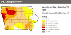
“So you’re not getting a lot of water out of that snowpack, number one,” Glisan says, “but if the drier soils are frozen deeper, it’s going to take a while for those profiles to thaw late winter/early spring, so even if you’re melting that snowpack, a lot of that’s not infiltrating, it’s running off.”
Much of Iowa, Nebraska and South Dakota has been in a significant drought for most of the last two years.


