712 Digital Group - top

HSEMD, State Agencies and Private Partners Assist Army Corps of Engineers with Raising Levee Near Hamburg

News

June 14th, 2011 by Ric Hanson

Des Moines–The Iowa Homeland Security and Emergency Management Division (HSEMD) is working with multiple state agencies and private companies to procure and transport materials to build up the secondary levee being constructed near Hamburg, Iowa.

The U. S. Army Corps of Engineers Omaha District notified HSEMD this afternoon that based on new data, the Missouri River levels at Hamburg will be higher. The Army Corps said the secondary levee needs to be built up an additional three feet, which will be accomplished through the placement of 14,000 linear feet, or roughly three miles, of HESCO barrier within the next 48 hours.

Ten-thousand tons of material from Hallett Materials in Shenandoah and Schildberg  Construction in Atlantic and Malvern  will be used to fill the HESCO barriers. HSEMD has procured the materials and is coordinating transportation through the Iowa Department of Transportation, the Iowa National Guard, JMT Trucking and Schildberg Construction. At its peak, transportation of these materials will involve 64 trucks, transporting more than 500 loads.

The Iowa National Guard will be placing the HESCO barriers on the levee and the Army Corps of Engineers will fill the barriers with the trucked-in materials. The Corps has been working to construct this secondary levee to protect Hamburg for the past several days.

For more information on Army Corps’ efforts on the secondary levee at Hamburg, visit the U.S. Army Corps of Engineers Omaha District website at http://www.nwo.usace.army.mil/ and click on the “Spring 2011 Flood Response Information” icon.

Flood barrier installed along I-29 near Hamburg

News

June 13th, 2011 by Ric Hanson

AMES, Iowa – June 13, 2011 – The Iowa Department of Transportation (DOT) is reporting the U.S. Army Corps of Engineers (USACE) is extending a temporary flood barrier around the south side of Hamburg to include a portion of Interstate 29. 

An approximate half-mile stretch of flood barrier will be placed on the shoulder of northbound I-29 between mileposts 0.4 and 0.9. This will require closure of the right lane of northbound I-29 at this location as the barrier is installed. The USACE will be using temporary barrier devices not commonly seen in Iowa. They were last used in the state during the 2008 floods in eastern Iowa. The devices are called Concertainers, produced by HESCO Bastion USA in Hammond, La. A Concertainer© is a galvanized, welded mesh (cage-like) container lined with heavy-duty fabric that is filled with locally available material such as sand, gravel or soil using a front-end loader.

These units expedite flood-protection work by eliminating the labor-intensive and time-consuming process of filling individual sandbags. When filled and connected, the Concertainer units create a sturdy barrier wall. Earlier today, the USACE levee located in Atchison County, Mo., breached and flood waters are expected to impact I-29 and Iowa 333 within the next 48 hours. There is no immediate threat to the roads.

Governor Branstad issues proclamation providing relief to vehicle dealers and recyclers

News

June 13th, 2011 by Ric Hanson

AMES, Iowa – June 13, 2011 – Iowa Governor Terry E. Branstad has issued a
proclamation of disaster emergency to assist Iowa motor vehicle and travel trailer
dealers, and vehicle recyclers whose businesses are directly impacted by the
Missouri River flooding. 

Various Iowa Code provisions and fees pertaining to the principle place of business
and additional lots for the sale of new and used motor vehicles and travel trailers,
and for performing vehicle recycling in Iowa have been temporarily suspended due to
the Missouri River flooding.  
Complete details are outlined in the proclamation. 

This 30-day suspension will allow businesses to move vehicles and establish lots
away from their principle place of business when affected by flooding. Disaster
counties include Fremont, Harrison, Mills, Monona, Pottawattamie and Woodbury. 

Affected dealers and recyclers should contact the Iowa Department of
Transportation’s Office of Vehicle Services at 515-237-3110, Monday through Friday 8
a.m. to 4:30 p.m., or visit http://www.iowadot.gov/mvd/ovs/misc.htm, for information
on how to obtain a temporary extension lot license.

A copy of the proclamation and answers to the most commonly asked questions about
its provisions can be found at:
http://www.iowadot.gov/emergencyProclamation2011.html

Threat of Iowa 2 closure becomes more imminent

News

June 13th, 2011 by Ric Hanson

AMES, Iowa - June 13, 2011; 4:30 p.m. – The Iowa Department of Transportation (DOT)
is reporting that flood waters are creeping farther onto the eastbound lanes of Iowa
2 in Fremont County and high winds are causing considerable movement of the waters
nearby. 

Iowa 2 serves as the connection between Iowa and Nebraska City, Nebr. The right
eastbound lane is already closed; the westbound lanes are still open. 

Flood and ground water levels are expected to rise in the area in the coming days.
Rain is also forecast on and off through Thursday. The combination of these
conditions makes the eventual road closure more imminent. 

Recognizing the importance of this highway to the region, the Iowa DOT will keep the
road open just as long as it is safe to do so. The public will be notified when it
is necessary to close the road. 

Traveler safety 
For public safety, the speed limit on the roadway is being reduced. Travelers should
keep their attention focused on the driving task and exercise additional caution at
night when it is more difficult to see a water-covered roadway. Look at the road
ahead instead of nearby flooding, and be on the alert for drivers who may slow down
or stop.       

Key traveler information resources:
·         Iowa DOT’s flood information call center 866-452-8510, open from 7 a.m. to
9 p.m. daily, speak to an operator for travel assistance
·         Road condition information 24 hours a day: visit www.511ia.org, or call
511 (in Iowa) or 800-288-1047 (outside of the state) for a recorded message of road
closures

Snowpack is the culprit for part of the Missouri River flooding

News

June 13th, 2011 by Ric Hanson

Part of the cause of the Missouri River flooding in western Iowa is the deep snow pack in the Rocky Mountains. John Lawson is the Wyoming Area Manager for the Great Plains Region of the U-S Bureau of Reclamation. The office manages reservoirs and dams far upriver from the Missouri and Lawson says the scene for the current flooding was set months ago. “We started getting a snow pack building way above average early on, even as early as February and it continued on until we finally got to record heights of snow pack,” he says. Snow pack refers to the amount of water contained in the snow, and while the bureau’s records on snow pack only date back to the early 1980s, Lawson says people have been measuring river flows for much longer.

He says, “We are forecasting inflows into our reservoir system that you would have to go back to somewhere around 1917 to find the kind of flows that we’re talking about and that we’re predicting that we’re going to get over the next 30 to 45 days.” While Iowa’s already seen temperatures topping off in the 90s and even above 100-degrees, Lawson says the record snow pack in Wyoming hasn’t melted much yet.

“We’re about 327% above average with regard to water content in the snow,” Lawson says. “We are dealing with a very unusual situation. Actually, it’s a situation we have no records of to judge by.” Lawson says the bureau has been releasing water from reservoirs upstream in anticipation of the melting snow. Iowans along the Missouri River are being warned the flooding could last for many weeks, even months.

(Matt Kelley/Radio Iowa)

Floodwaters burst through levee, bound for Hamburg

News

June 13th, 2011 by Ric Hanson

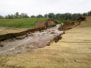
Levee Breach near Hamburg. Photo courtesy IA Emergency Mgmt

A levee along the Missouri River failed this morning in northwest Missouri, prompting a flash flood warning for the southwest Iowa town Hamburg. Hamburg Fire Chief Dan Sturm witnessed the failure at 9:50 a.m. in an area where three partial breaches occurred last week.  “We were down getting ready to ring some sand boils and actually watched the breach occur,” Sturm said.

“This time, instead of sealing itself off, it tended to blow itself out.” Floodwaters started gushing through the gap – which widened to more than 30 feet in less than an hour. “There really wasn’t anything we could do to stop it at that point,” Sturm said. “We pulled everybody back to start preparations for sealing off the town with the secondary levee.”

The breached levee is located a several miles from Hamburg, so it could be tomorrow (Tuesday) before the floodwaters reach town. But, National Weather Service hydrologist Dave Pearson says the gap in the levee is growing bigger every hour.

“So, as that breach becomes wider, the amount of water moving in increases and that decreases the time it takes to get to the interstate and Hamburg,” Pearson said. A spokesperson for the Iowa Department of Transportation says a 20 mile section of Interstate 29 will be closed from Iowa Highway 2 to south of Rock Port, Missouri. The I-29 closure is expected today or tomorrow. Pearson says flood predictions for Hamburg remain unchanged.

“At no point did the Corps of Engineers think this portion of the levee would hold. It was a foregone conclusion that it was going to fail. it was a matter of when, not if,” Pearson said. A secondary levee was built last week to protect Hamburg. It’s not clear if the structure will be strong enough to protect the town of about 1,100 people from the deepening floodwaters. Hundreds of people have already fled their homes and businesses. The Army Corps of Engineers projects, if the secondary levee fails, 8 feet to 10 feet of floodwater would pour into the southern part of Hamburg.

(Pat Curtis/Radio Iowa)

Gov. Branstad launches second week of “Working Together for a Better Future” tour

News

June 13th, 2011 by Ric Hanson

(DES MOINES) – Gov. Terry E. Branstad today (Monday) announced his “Working Together for a Better Future” tour will be coming to Atlantic, Audubon and Carroll, this week. The stops are part of his 43-city tour that began last week. Branstad said he’s traveling the state to discuss the budget and his administration’s plans to restore “honest budgeting practices.”

The tour is designed to provide Iowans information regarding his administration’s plan to “Build a strong fiscal foundation for the future and create jobs in Iowa.”
This Wednesday, Branstad stops in Carroll, where, at 3-p.m.,  he will speak at the Pizza Ranch restaurant. At 4:30, he’s scheduled to be in Audubon, for a meeting with the  Audubon County Economic Development Group at  800 Market Street. And, at 5:45, Branstad will be at the  Rock Island Train Depot in Atlantic.
For more information, visit http://www.Governor.Iowa.gov

Iowa DOT closing I-29/680 interchange near Loveland at 6 p.m. today

News

June 13th, 2011 by Ric Hanson

AMES, Iowa – June 13, 2011; 3 p.m. – The Iowa Department of Transportation (DOT) is
reporting that it will be closing the Interstate 29/680 interchange near Loveland at
6 p.m. today. 

This will result in closures being placed at the following locations. 
·         I-680 west- and eastbound from milepost 21 near Beebeetown
(Pottawattamie/Harrison County Road L-34) to the I-29/680 interchange (milepost 71
near Loveland).  
·         I-29 south- and northbound lanes from the I-29/680 interchange to the
I-29/U.S. 30 interchange (milepost 75 near Missouri Valley).

Local and I-29 regional corridor traffic (Iowa, Missouri, Nebraska, South Dakota)
·         Follow the posted local detours or call the Iowa DOT’s flood hotline at
1-866-452-8510 from 7 a.m. to 9 p.m. daily for personal traveler assistance.  
·         After hours, call 511 (in Iowa) or 800-288-1047 (out of state) for a
recorded message of closed roads.
·         View the flooded Iowa roads map for road closures, detours and areas at
risk of flooding - http://tinyurl.com/3o2mtlp
National interstate travelers
For interstate travelers planning to use I-29 simply to travel through Iowa, the
Iowa DOT suggests selection of an interstate route that avoids the flood-warned area
along the Missouri River corridor entirely. Travelers can utilize any of the other
interstate routes that remain available. 

Interstate routes not expected to be impacted by flood waters:
·         I-80 from east to west across the entire state 
·         I-35 from north to south across the entire state
·         I-235 in Des Moines metro area
·         I-380 from Iowa City to Waterloo
·         I-74 and I-280 in the Quad Cities
·         I-480 bridge between Council Bluffs and Omaha
I-29 remains vulnerable to additional closures due to the flooding. After the
I-29/680 interchange is closed, I-29 will be closed from milepost 55 in Council
Bluffs to milepost 75 near Missouri Valley.

King Inspects Flooding Throughout Western Iowa

News

June 13th, 2011 by Ric Hanson

Washington D.C.- Congressman Steve King (R-IA) has traveled throughout the 5th District to inspect the impact of Missouri River flooding on local communities. As part of his survey, King made stops in Woodbury, Monona, Pottawattamie and Fremont counties.

Congressman Steve King (right) discusses flood preparation efforts in Pottawattamie County with Mayor Tom Hanafan of Council Bluffs during a June 9 briefing held at the Emergency Operations Command Center in Council Bluffs.

At each stop, King examined the extent of area flooding and received briefings on actions that local communities are taking to implement emergency management procedures to safeguard the lives and property of Iowans. King also participated in an aerial survey of Missouri River flooding, viewing the flood’s effects from the southern tip of the Fifth district to Gav

in’s Point in Yankton, South Dakota.
“The Missouri River flood is affecting communities throughout western Iowa, and the scope and scale cannot be understood fully until it is seen firsthand,” said King. “Homes are being flooded, crops are being destroyed, businesses are being closed, and, unfortunately, the flood waters will not be receding anytime soon. According to the U.S. Army Corps of Engineers, this will be a historic flood. It is exactly the kind of natural disaster that requires a coordinated response from all levels of government- local, state and federal.”

“I will be working with the Governor’s office, and with my colleagues in Congress, to ensure that communities throughout western Iowa have access to the federal resources that are available to help them protect their citizens and infrastructure, and to help them recover. I also want to express my appreciation for everyone who is volunteering their time to assist with flood prevention efforts. Sandbags do not fill or place themselves, and it has been inspiring to watch Iowans band together to do the hard work that is necessary to keep the water out.”

(Press Release from the office of Cong. KIng)

The latest word on the flood situation

News

June 13th, 2011 by Ric Hanson

The Iowa Homeland Security and Emergency Management Division (HSEMD) continues to work closely with personnel from the Iowa National Guard, Department of Human Services, Department of Public Safety, Department of Transportation, Department of Natural Resources and other agencies as appropriate at the State Emergency Operations Center (SEOC) in response to the flooding situation in Western Iowa. 

Here are the latest developments:

  • IA National Guard personnel have been requested to patrol levees in Mills and Pottawattamie Counties. Guard personnel began patrolling levees in Woodbury County over the weekend.

Missouri River crossings

1.       The Iowa DOT is expecting the Missouri River crossings at the following locations to remain open during the flooding

2.       Sioux City: U.S. 77/U.S.20 to South Sioux City, Nebr.; and U.S. 20/U.S. 75 to Nebraska

3.       Council Bluffs/Omaha: I-480 and I-80

o   Call center established for road closures:  1-866-452-8510

  • Iowa State Patrol will be assisting Fremont County Sheriff’s Dept. with enhanced security patrols along the I-29 corridor where residents have evacuated. There are no reports of looting at this time.