w/ Dr. Keith Leonard
Podcast: Play in new window | Download (3.9MB)
Subscribe: RSS
Jim Field speaks with some of the top graduating seniors from CAM High School, Ali Hosfelt and Matthew Williamson.
Podcast: Play in new window | Download (7.2MB)
Subscribe: RSS
The Western Iowa Conference track meet that was postponed Tuesday night due to lightning will not be completed. The conference officials were hoping to complete the final 13 events Wednesday night but more bad weather wouldn’t allow it. The conference will award the individual events that were completed and honor the athletes who broke conference records. There will be no team champions crowned this year. Here are the full results: WIC HS Results
Girls event winners include:
Boys event winners include:
COUNTIES: SHELBY-POTTAWATTAMIE-MILLS-MONTGOMERY-FREMONT-PAGE-…WINTER WEATHER ADVISORY REMAINS IN EFFECT UNTIL 10 AM CDT THIS MORNING…
* TIMING...OCCASIONAL LIGHT SNOW WILL CONTINUE THIS MORNING. * ACCUMULATIONS…ADDITIONAL SNOW ACCUMULATIONS LESS THAN INCH IS EXPECTED.
* IMPACTS...ROADS WILL REMAIN SLUSHY AND SLICK.
COUNTIES:GUTHRIE-DALLAS-POLK-CASS-ADAIR-MADISON-ADAMS-UNION-TAYLOR– …WINTER WEATHER ADVISORY REMAINS IN EFFECT UNTIL 1 PM CDT THIS AFTERNOON…
* SHORT TERM TRENDS...SNOW OR A MIX OF RAIN SLEET AND SNOW WILL SWITCH TO ALL SNOW IN THE MORNING HOURS AND CONTINUE THROUGH EARLY THURSDAY AFTERNOON.
* STORM TOTAL SNOW ACCUMULATIONS…3 TO 5 INCHES WITH LOCALLY HIGHER AMOUNTS. SNOWFALL RATES OF 1 TO NEAR 2 INCHES PER HOUR CAN BE EXPECTED AT TIMES AND SNOW WILL ACCUMULATE QUICKLY. THUNDERSTORMS MAY ALSO OCCUR AND WILL PRODUCE LOCALLY HIGHER SNOWFALL AMOUNTS.
* WINDS/VISIBILITY…A NORTH WIND AT 20 TO 35 MPH WILL REDUCE VISIBILITY TO LESS THAN A HALF MILE AT TIMES. * IMPACTS…ROADS ARE EXPECTED TO BECOME SNOW COVERED AND SLUSHY AS THE SNOW INTENSIFIES THIS MORNING. HEAVY WET SNOW MAY ACCUMULATE ON POWER LINES AND LEAFY TREES…WHICH MAY LEAD TO DAMAGE.
COUNTIES: CRAWFORD-CARROLL-AUDUBON- …WINTER WEATHER ADVISORY REMAINS IN EFFECT UNTIL 10 AM CDT THIS MORNING… *
SHORT TERM TRENDS...SNOW OR A MIX OF RAIN SLEET AND SNOW CONTINUE THROUGH MID THURSDAY MORNING.
* STORM TOTAL SNOW ACCUMULATIONS…3 TO 5 INCHES WITH LOCALLY HIGHER AMOUNTS. SNOWFALL RATES OF 1 TO NEAR 2 INCHES PER HOUR CAN BE EXPECTED AT TIMES AND SNOW WILL ACCUMULATE QUICKLY. THUNDERSTORMS MAY ALSO OCCUR AND WILL PRODUCE LOCALLY HIGHER SNOWFALL AMOUNTS.
* WINDS/VISIBILITY…A NORTH WIND AT 20 TO 35 MPH WILL REDUCE VISIBILITY TO LESS THAN A HALF MILE AT TIMES.
PRECAUTIONARY/PREPAREDNESS ACTIONS… A WINTER WEATHER ADVISORY MEANS THAT PERIODS OF SNOW…SLEET…OR FREEZING RAIN WILL CAUSE TRAVEL DIFFICULTIES. BE PREPARED FOR SLIPPERY ROADS AND LIMITED VISIBILITIES…AND USE CAUTION WHILE DRIVING.
Rain and heavy snow combined for a wet Wednesday evening and Thursday morning here in Atlantic. The 24-hour snow total was 2-inches. But when you combine that heavy, wet snow with the rainfall we received late Wednesday into early this morning, the precipitation value was 3.07-inches here in Atlantic. (as of 8-a.m., we had received 2.3″ at the KJAN Studios, and the snow had stopped)

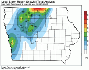
Estimated snowfall totals across Iowa through 7:40-a.m. Thursday. Courtesy Iowa Environmental MesoNet.
In Massena, Ardell reported 1.75-inches of rain and 1-inch of snow, as of 7-a.m. Other reports include: Irwin, 4-inches of snow & 2.19 liquid moisture; Oakland, 3″ of snow; Villisca, 2″; Clarinda 1.9″; Avoca, 3″ snow/2.05″ liquid value.
The National Weather Service in Des Moines said Jamaica, in Guthrie County, had 3.1-inches of snow through 6-am; Near Earlham, in Dallas County, 2.1-inches of snow was reported at 7-a.m.; Sac City in northwest Iowa’s Sac County had 5-inches of snow as of 7-a.m., and the National Weather Service office in Valley, NE., reported 3-inches of snow as of 7:20-a.m., while Omaha had 3.1 inches.
If you have a snow and/or rainfall total you would like to report. Call us at 1-800-283-5526 or e-mail kjannews@metc.net.
OMAHA, Neb. (AP) – A spring storm has slathered a heavy icing of slushy snow on parts of eastern Nebraska and western and north-central Iowa. Our 24-hour snowfall total in Atlantic as of 7-a.m. was 2-inches.
In the past 12 hours, more than 6 inches has been recorded in isolated parts of Iowa, including Harrison County near Omaha, Neb., and along the Minnesota border in northern Iowa. Nebraska totals are generally lower.
National Weather Service meteorologist Josh Boustead called the May storm “really, really unusual.” He says that in Omaha, for example, measurable snow has fallen only four times since 1884. The storm is moving east and is expected to lay a wet blanket on Des Moines later Thursday.
The (Podcast) forecast for Atlantic & the KJAN listening area, weather announcements and stats for Atlantic….
Podcast: Play in new window | Download (1.2MB)
Subscribe: RSS
COUNTIES: GREENE-GUTHRIE-DALLAS-CASS-ADAIR-MADISON-ADAMS-UNION-TAYLOR
414 AM CDT THU MAY 2 2013

...WINTER WEATHER ADVISORY IN EFFECT UNTIL 1 PM CDT THIS AFTERNOON...

THE NATIONAL WEATHER SERVICE IN DES MOINES HAS ISSUED A WINTER WEATHER ADVISORY FOR HEAVY WET SNOW...WHICH IS IN EFFECT UNTIL 1
PM CDT THIS AFTERNOON.

* SHORT TERM TRENDS...SNOW OR A MIX OF RAIN SLEET AND SNOW WILL
  SWITCH TO ALL SNOW IN THE MORNING HOURS AND CONTINUE THROUGH
  EARLY THURSDAY AFTERNOON.

* STORM TOTAL SNOW ACCUMULATIONS...3 TO 5 INCHES WITH LOCALLY
  HIGHER AMOUNTS. SNOWFALL RATES OF 1 TO NEAR 2 INCHES PER HOUR
  CAN BE EXPECTED AT TIMES AND SNOW WILL ACCUMULATE QUICKLY.
  THUNDERSTORMS MAY ALSO OCCUR AND WILL PRODUCE LOCALLY HIGHER
  SNOWFALL AMOUNTS.

* WINDS/VISIBILITY...A NORTH WIND AT 20 TO 35 MPH WILL REDUCE
  VISIBILITY TO LESS THAN A HALF MILE AT TIMES.

* IMPACTS...ROADS ARE EXPECTED TO BECOME SNOW COVERED AND SLUSHY
  AS THE SNOW INTENSIFIES THIS MORNING. HEAVY WET SNOW MAY
  ACCUMULATE ON POWER LINES AND LEAFY TREES...WHICH MAY LEAD TO
  DAMAGE.

PRECAUTIONARY/PREPAREDNESS ACTIONS...

A WINTER WEATHER ADVISORY FOR SNOW MEANS THAT PERIODS OF SNOW
WILL CAUSE TRAVEL DIFFICULTIES. BE PREPARED FOR SNOW COVERED
ROADS AND LIMITED VISIBILITY...AND USE CAUTION WHILE DRIVING.