United Group Insurance

Hazardous Weather Outlook (Update) for western Iowa

Weather

May 19th, 2013 by Ric Hanson

COUNTIES: SAC-CRAWFORD-CARROLL-AUDUBON-GUTHRIE-DALLAS-CASS-ADAIR-MADISON-ADAMS-UNION-TAYLOR-RINGGOLD

248 PM CDT SUN MAY 19 2013

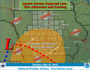
THIS AFTERNOON AND TONIGHT MORE WIDESPREAD THUNDERSTORM ACTIVITY IS EXPECTED TO DEVELOP BY EARLY EVENING AND SPREAD NORTHEAST ACROSS THE AREA INTO TONIGHT. SIGNIFICANT SEVERE WEATHER IS EXPECTED WITH THESE STORMS LATER THIS AFTERNOON INTO THE EVENING WITH ALL MODES OF SEVERE WEATHER POSSIBLE. GOLF BALL HAIL…DAMAGING SURFACE WINDS IN EXCESS OF 60MPH AND A FEW TORNADOES WILL BE POSSIBLE DURING THIS TIME.

MONDAY THROUGH SATURDAY….SCATTERED THUNDERSTORMS ARE EXPECTED FROM TIME TO TIME ON MONDAY INTO EARLY WEDNESDAY. THERE IS THE THREAT FOR SEVERE WEATHER MONDAY AFTERNOON INTO THE EVENING AS WELL AS AGAIN ON TUESDAY AFTERNOON AND EVENING. MAIN THREAT WILL BE FROM LARGE HAIL AND DAMAGING WINDS ALTHOUGH AN ISOLATED TORNADO CANNOT BE RULED OUT.

.SPOTTER INFORMATION STATEMENT…

SPOTTER ACTIVATION WILL BE NEEDED LATER THIS AFTERNOON INTO THE EVENING FOR THE OUTLOOK AREA. ADDITIONAL SPOTTER ACTIVATION MAY BE NEEDED FROM TIME TO TIME EARLY IN THE WORK WEEK.

Maker of ‘pink slime’ continues to struggle

Ag/Outdoor

May 19th, 2013 by Ric Hanson

SIOUX CITY, Iowa(AP) — The beef-processing company that makes the product that critics call “pink slime” continues to struggle more than a year after the initial stories on the lean bits of beef that Beef Products Inc. produced. The Sioux City Journal reports the Dakota Dunes, S.D., based company lost 80 percent of its business after the uproar over what BPI calls lean finely textured beef.

The meat BPI separated from trimmings and treated with ammonia to kill bacteria was widely used in hamburger, but consumers objected to it after media reports depicted it as unsavory. The private company closed three of its four plants, scrapped expansion plans in South Sioux City and eliminated more than 700 jobs. Those won’t return soon.

Tornado Watch Issued for parts of southwest Iowa

Weather

May 19th, 2013 by Ric Hanson

TORNADO WATCH NUMBER 181 NWS STORM PREDICTION CENTER NORMAN OK

150 PM CDT SUN MAY 19 2013

THE NWS STORM PREDICTION CENTER HAS ISSUED A  TORNADO WATCH FOR PORTIONS OF SOUTHWEST IOWA, CENTRAL AND EASTERN KANSAS WEST CENTRAL AND NORTHWEST MISSOURI SOUTHEAST NEBRASKA EFFECTIVE THIS SUNDAY AFTERNOON AND EVENING FROM 150 PM UNTIL 1000 PM CDT. IN SOUTHWEST IOWA, THE WATCH CURRENTLY INCLUDES FREMONT AND PAGE COUNTIES.

* PRIMARY THREATS INCLUDE…

SEVERAL TORNADOES LIKELY WITH A FEW INTENSE TORNADOES POSSIBLE NUMEROUS LARGE HAIL EVENTS LIKELY WITH A FEW VERY LARGE HAIL EVENTS TO 3 INCHES IN DIAMETER POSSIBLE SEVERAL DAMAGING WIND GUSTS LIKELY WITH A FEW SIGNIFICANT GUSTS TO 80 MPH POSSIBLE THE TORNADO WATCH AREA IS APPROXIMATELY ALONG AND 115 STATUTE MILES EAST AND WEST OF A LINE FROM 35 MILES NORTH NORTHWEST OF FALLS CITY NEBRASKA TO 45 MILES SOUTH OF WICHITA KANSAS.

PRECAUTIONARY/PREPAREDNESS ACTIONS…

REMEMBER…A TORNADO WATCH MEANS CONDITIONS ARE FAVORABLE FOR TORNADOES AND SEVERE THUNDERSTORMS IN AND CLOSE TO THE WATCH AREA. PERSONS IN THESE AREAS SHOULD BE ON THE LOOKOUT FOR THREATENING WEATHER CONDITIONS AND LISTEN FOR LATER STATEMENTS AND POSSIBLE WARNINGS.

Iowa lawmakers ponder a special session

News

May 19th, 2013 by Ric Hanson

DES MOINES, Iowa (AP) – As lawmakers try to adjourn the legislative session, some wonder whether the best way to deal with a contentious health debate is to skip the matter for now and hold a special session later.  It’s been seven years since the Legislature held a special session, but they have been used sporadically over the years to address complex issues.

In the past 50 years, lawmakers have joined for 15 special sessions. There were five years when two special sessions were called.  This time around, some lawmakers think a discussion over whether to expand Medicaid may be too complicated to finish in the coming days.   House Speaker Kraig Paulsen says he doesn’t want to rush the process.  But Democratic Sen. Jack Hatch says lawmakers should stay until the job is done.

NWS Forecast for Atlantic & the KJAN listening area

Weather

May 19th, 2013 by Ric Hanson

(National Weather Service/update 5:26-a.m.)

Today: Showers and thunderstorms, mainly after 3pm. Some of the storms could be severe. High near 83. Breezy, with a south southeast wind 8 to 18 mph, with gusts as high as 26 mph. Chance of precipitation is 80%. New rainfall amounts between a quarter and half of an inch possible.
Tonight: Showers and thunderstorms, mainly before 1am. Some of the storms could be severe. Low around 62. South wind 9 to 14 mph, with gusts as high as 20 mph. Chance of precipitation is 80%. New rainfall amounts between a half and three quarters of an inch possible.

Monday: A 20 percent chance of showers and thunderstorms before 10am. Partly sunny, with a high near 79. Breezy, with a south southwest wind 11 to 20 mph, with gusts as high as 30 mph.
Monday Night: A 30 percent chance of showers and thunderstorms. Mostly cloudy, with a low around 59. South southwest wind 6 to 13 mph, with gusts as high as 24 mph. New rainfall amounts of less than a tenth of an inch, except higher amounts possible in thunderstorms.

Tuesday: A 30 percent chance of showers and thunderstorms. Partly sunny, with a high near 71. Southwest wind 5 to 11 mph. New rainfall amounts of less than a tenth of an inch, except higher amounts possible in thunderstorms.
Tuesday Night: A 30 percent chance of showers and thunderstorms. Mostly cloudy, with a low around 54. New rainfall amounts of less than a tenth of an inch, except higher amounts possible in thunderstorms.

Wednesday: A 30 percent chance of showers and thunderstorms. Mostly cloudy, with a high near 67.
Wednesday Night: A slight chance of showers. Mostly cloudy, with a low around 53. Chance of precipitation is 20%.

Listen for severe weather bulletins this afternoon/evening

Weather

May 19th, 2013 by Ric Hanson

The National Weather Service in Des Moines says scattered thunderstorms will be possible today (Sunday) across central Iowa. However, the thunderstorms will become much more numerous by mid to late afternoon and spread northeast across the state tonight. Large hail, damaging winds and even a few tornadoes are expected with the storms by late afternoon into the evening. Localized heavy rainfall will also be possible, especially in portions of western into northern Iowa late today into tonight.

Hazardous Weather Outlook: May 19th-21st

News, Weather

May 19th, 2013 by Ric Hanson

AREA COUNTIES: SAC-CRAWFORD-CARROLL-AUDUBON-GUTHRIE-DALLAS-CASS-ADAIR-MADISON-ADAMS-UNION-TAYLOR- RINGGOLD

503 AM CDT SUN MAY 19 2013

ISOLATED TO SCATTERED THUNDERSTORMS ARE EXPECTED DURING THE DAY WITH A SEVERE STORM POSSIBLE PRODUCING LARGE HAIL OR A DAMAGING WIND GUST. HOWEVER…MUCH MORE WIDESPREAD THUNDERSTORM ACTIVITY IS EXPECTED TO DEVELOP BY MID TO LATE AFTERNOON AND SPREAD NORTHEAST ACROSS THE AREA INTO TONIGHT.

SIGNIFICANT SEVERE WEATHER IS EXPECTED WITH THESE STORMS LATER THIS AFTERNOON INTO THE EVENING WITH ALL MODES OF SEVERE WEATHER POSSIBLE. GOLF BALL HAIL…DAMAGING SURFACE WINDS IN EXCESS OF 60MPH AND A FEW TORNADOES WILL BE POSSIBLE DURING THIS TIME.

MONDAY AND TUESDAY…SATURDAY SCATTERED THUNDERSTORMS ARE EXPECTED FROM TIME TO TIME ON MONDAY INTO EARLY WEDNESDAY. THERE IS THE THREAT FOR SEVERE WEATHER MONDAY AFTERNOON INTO THE EVENING AS WELL AS AGAIN ON TUESDAY AFTERNOON AND EVENING. MAIN THREAT WILL BE FROM LARGE HAIL AND DAMAGING WINDS ALTHOUGH AN ISOLATED TORNADO CANNOT BE RULED OUT.

SPOTTER INFORMATION STATEMENTSPOTTER ACTIVATION WILL BE NEEDED LATER THIS AFTERNOON INTO THE EVENING FOR THE OUTLOOK AREA. ADDITIONAL SPOTTER ACTIVATION MAY BE NEEDED FROM TIME TO TIME EARLY IN THE WORK WEEK.

JOYCE E. WRIGHT, 86, of Casey (Svcs. 5-23-2013)

Obituaries

May 19th, 2013 by Ric Hanson

JOYCE E. WRIGHT, 86, of Casey , died Sat., May 18th, at the Cass County Memorial Hospital in Atlantic. Funeral services for JOYCE WRIGHT will be held at 10:30 AM Thurs., May 23rd at United Methodist Church in Casey. Hockenberry Family Care Funeral Home in Atlantic has the arrangements.

Visitation with the family will be from 9:30 to 10:30 AM Thurs., May 23rd at the United Methodist Church in Casey.

Burial will be in the Dalmanutha Cemetery in Casey.

JOYCE WRIGHT is survived by:

Sons, Robert (Donna) Wright of Laurel, Delaware; Dick (Jan) Wright of Ames; and Verle (Joyce) Wright of Marshall, VA

Daughter, Renae (Greg) Wedemeyer of Adair

12 grandchildren and 10 great-grandchildren.


Sidney woman arrested for OWI test failure

News

May 19th, 2013 by Ric Hanson

Sheriff’s officials in Montgomery County report the arrest early this (Sunday) morning, of a Fremont County woman. 41-year old Jill Lynn Davalos, of Sidney, was taken into custody just before 2-a.m., for driving while revoked following an OWI test failure. She was booked into the Montgomery County Jail and held on $1,000 cash bond.

Red Oak Police make drug arrest

News

May 19th, 2013 by Ric Hanson

Police in Red Oak report the arrest late Saturday night of 37-year old Rachel Charise Kathleen Hadden, of Red Oak. Hadden was taken into custody in the 400 block of east Senate Avenue, on a warrant charging her with a felony controlled substance violation. Hadden was booked into the Montgomery County Jail and held, on $50,000 bond.