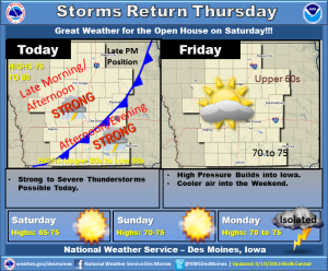
Jim Field speaks with Jeff Johnson, Warning Coordinator Meteorologist with the National Weather Service in Des Moines, about an open house coming up this weekend.
Podcast: Play in new window | Download (3.8MB)
Subscribe: RSS
Jim Field speaks with Jeff Johnson, Warning Coordinator Meteorologist with the National Weather Service in Des Moines, about an open house coming up this weekend.
Podcast: Play in new window | Download (3.8MB)
Subscribe: RSS
A cold front will move across the state today, reaching central Iowa by late in the evening, and southeast of Iowa later tonight. Thunderstorms will develop along the front today with some severe weather possible late this afternoon and early evening. Cooler weather will overspread the area for the weekend with highs in the upper 60s to mid 70s. Lows will be in the 40s to mid 50s, with a few upper 30s in the north Saturday Morning.
14 AM CDT THU SEP 19 2013
…STRONG GUSTY WINDS WITH THUNDERSTORMS OVER WEST CENTRAL IOWA…
AT 707 AM CDT…NATIONAL WEATHER SERVICE DOPPLER RADAR INDICATED A
CLUSTER OF STRONG THUNDERSTORMS OVER EAST CENTRAL CASS AND WEST
CENTRAL ADAIR COUNTIES…MOVING NORTHEAST AT 30 MPH.
WINDS OF 40 TO 50 MPH ARE POSSIBLE WITH THESE STORMS.
LOCATIONS IMPACTED INCLUDE…
FONTANELLE…
GUSTY WINDS MAY CAUSE SMALL BRANCHES TO BE BLOWN DOWN…AND LOOSE
OBJECTS TO BLOW AROUND. SEEK SHELTER IN A STURDY STRUCTURE UNTIL THIS
STORM HAS PASSED.
From the Cass and Audubon County FSA and NRCS offices w/ Max Dirks.
Podcast: Play in new window | Download (1.8MB)
Subscribe: RSS
ADAIR-AUDUBON-CARROLL-CASS-GREENE-GUTHRIE-
619 AM CDT THU SEP 19 2013
…LINE OF THUNDERSTORMS PRODUCING STRONG WINDS OVER WEST CENTRAL IOWA…
AT 616 AM CDT…NATIONAL WEATHER SERVICE DOPPLER RADAR INDICATED
STRONG THUNDERSTORMS ALONG A LINE EXTENDING FROM SOUTHWEST GREENE COUNTY TO SOUTH CENTRAL CASS COUNTY…MOVING NORTHEAST AT 30 MPH.
WINDS UP TO 50 MPH AND OCCASIONAL CLOUD TO GROUND LIGHTNING ARE
POSSIBLE WITH THESE STORMS.
LOCATIONS IMPACTED INCLUDE…
BAYARD… ANITA… CUMBERLAND…
MASSENA… ADAIR… BRIDGEWATER…
BAGLEY… GUTHRIE CENTER… YALE…
PANORA… JAMAICA… CASEY…
GUSTY WINDS MAY CAUSE SMALL BRANCHES TO BE BLOWN DOWN…AND LOOSE
OBJECTS TO BLOW AROUND. STAY AWAY FROM HIGH OBJECTS OUTDOORS SUCH AS
TREES. SEEK SHELTER IN A STURDY STRUCTURE UNTIL THESE STORMS HAVE
PASSED.
The Freese-Notis weather forecast for Atlantic & the KJAN listening area, and weather info. for Atlantic….
Podcast: Play in new window | Download (844.0KB)
Subscribe: RSS
Strong storms passing through western Iowa early this (Thursday) morning have caused damage in some locations. The National Weather Service in Des Moines says a trained spotter in Audubon reported winds gusting up to 60-miles per hour caused large tree branches to snap and fall four-miles east of the Audubon Airport, and some shingles were blown off a roof. A severe thunderstorm warning was issued for parts of Audubon, Cass, Adair and Guthrie Counties, just before 6-a.m.
A U-S-D-A survey finds the value of Iowa farmland and farm buildings rose dramatically in the past year. According to the U-S-D-A, Iowa farmland sold for an average price of 84-hundred dollars an acre in August — a 20 percent increase from the same month a year ago. No other Midwestern state is recording farm land values that high. The average price of farmland in Illinois in August was 78-hundred an acre; in Minnesota it was 47-hundred-50; in Wisconsin it was 44-hundred. Nebraska and Missouri farmland was selling for an average of about three-thousand an acre in August. In the Dakotas, it ranged from 17- to 18-hundred an acre. Economists say Iowa’s farm land price boom has been directly tied to farm income gains.
(Radio Iowa)
555 AM CDT THU SEP 19 2013
THE NATIONAL WEATHER SERVICE IN DES MOINES HAS ISSUED A
* SEVERE THUNDERSTORM WARNING FOR…
NORTHWESTERN ADAIR COUNTY IN SOUTHWEST IOWA…
EASTERN AUDUBON COUNTY IN WEST CENTRAL IOWA…
NORTHERN CASS COUNTY IN SOUTHWEST IOWA…
SOUTHWESTERN GREENE COUNTY IN WEST CENTRAL IOWA…
WESTERN GUTHRIE COUNTY IN WEST CENTRAL IOWA…
* UNTIL 615 AM CDT
* AT 548 AM CDT…SEVERE THUNDERSTORMS WERE LOCATED ALONG A LINE
EXTENDING FROM COON RAPIDS TO ATLANTIC…AND MOVING NORTHEAST AT 30
MPH.
HAZARD…60 MPH WIND GUSTS.
SOURCE…TRAINED WEATHER SPOTTERS. ESTIMATED 60 MPH WINDS CAUSING
TREE AND ROOF DAMAGE WERE REPORTED FOUR MILES EAST OF AUDUBON.
IMPACT…EXPECT DAMAGE TO ROOFS…SIDING AND TREES.
* LOCATIONS IMPACTED INCLUDE…
GUTHRIE CENTER…WIOTA…BAYARD…ANITA…BAGLEY AND ADAIR.
THIS INCLUDES INTERSTATE 80 BETWEEN MILE MARKERS 58 AND 81.
PRECAUTIONARY/PREPAREDNESS ACTIONS…
FOR YOUR PROTECTION MOVE TO AN INTERIOR ROOM ON THE LOWEST FLOOR OF A
BUILDING.