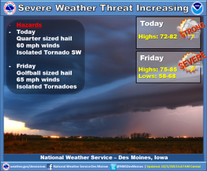
The National Weather Service says several rounds of thunderstorms are expected across Iowa today through Friday evening. There is a threat for severe weather over central and western Iowa this afternoon and evening with the potential for large hail and damaging winds. An isolated tornado is also possible. Additional storms are expected to develop over northern Iowa by Friday afternoon. Large hail, damaging winds and a few tornadoes are possible with this activity. One final line of storms will arrive Friday evening and will bring and additional severe weather threat. Storms will end Saturday as much cooler weather arrives. Sunday will remain cool with a few showers forecast over the northern half of the state. Seasonal and mainly dry conditions are expected for the start of next week.


