712 Digital Group - top

Red Oak man charged with OWI & open container

News

October 4th, 2013 by Ric Hanson

Police in Red Oak say a local man was arrested Thursday night on alcohol and other charges. 41-year-old Michael Scott Jones, of Red Oak, faces 2nd offense OWI and open container of alcohol charges, along with being cited for failure to display a registration plate and no proof of insurance.

Jones was being held in the Montgomery County Jail on $2,000 bond.

Hazardous Weather Outlook: Western/Central IA, 10/4/13

Weather

October 4th, 2013 by Ric Hanson

COUNTIES: SAC-CRAWFORD-CARROLL-AUDUBON-GUTHRIE-DALLAS

THERE IS A MODERATE RISK FOR SEVERE WEATHER LATE THIS AFTERNOON
AND THROUGH THE EVENING. ISOLATED THUNDERSTORMS ARE POSSIBLE THIS
MORNING THROUGH MID AFTERNOON WITH QUARTER SIZED HAIL AND 60 MPH
WINDS POSSIBLE. SIGNIFICANT SEVERE STORMS ARE POSSIBLE LATER TODAY
DURING THE MODERATE RISK TIME FRAME. VERY LARGE HAIL GOLF BALL
SIZED OR LARGER…70 MPH WINDS AND A FEW TORNADOES ARE ALL
POSSIBLE. A STRONG TORNADO MAY OCCUR.

SPOTTER ACTIVATION IS LIKELY FROM 3 PM TO MIDNIGHT TODAY.

COUNTIES: CASS-ADAIR-MADISON-ADAMS-UNION-TAYLOR-RINGGOLD

ISOLATED SEVERE THUNDERSTORMS ARE POSSIBLE THROUGH MID AFTERNOON
TODAY WITH QUARTER SIZED HAIL AND 60 MPH WINDS. A GREATER RISK FOR
SEVERE WEATHER IS EXPECTED AFTER 5 PM THROUGH MIDNIGHT AS A LINE
OF STORMS DEVELOP OVER WESTERN IOWA AND RACE EAST THROUGH THE
EVENING. HALF DOLLAR SIZED HAIL…65 MPH WINDS AND AN ISOLATED
TORNADO OR TWO MAY OCCUR WITH THIS ACTIVITY.

SPOTTER ACTIVATION IS LIKELY BETWEEN 5 PM AND MIDNIGHT.

Severe weather possible again today (Friday)

News, Weather

October 4th, 2013 by Ric Hanson

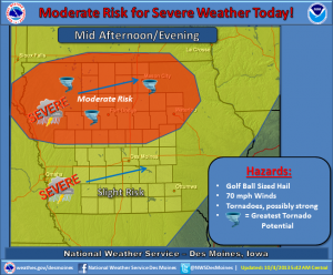
The National Weather Service says a moderate risk for severe weather is in place across northern Iowa this afternoon and evening while a slight risk encompasses much of the remainder of the state. Scattered thunderstorms will linger across the area this morning. An isolated severe storm with quarter sized hail and 60 mph winds are possible with this activity. A line of strong to severe storms is expected to develop over western Iowa by this afternoon.

(Graphic) - NWS Severe Weather potential.

(Graphic) – NWS Severe Weather potential.

That activity will race northeast and into the area from late afternoon through mid-evening. Very large hail, damaging winds and a few tornadoes are likely, especially over the moderate risk region. A few severe storms with a heightened risk for damaging winds are likely over central and northern Iowa along with an attendant large hail and isolated tornado threat. This could become a potentially dangerous situation.

Be prepared to take appropriate actions if severe weather approaches your location. The storms will begin to weaken after midnight. By Saturday, a strong cold front will be passing through the area, ushering in much colder temperatures. Thunderstorm chances will pass to the east with dry and windy conditions in place by the afternoon.

Hazardous Weather Outlook for parts of w/sw Iowa, 10/4/13

Weather

October 4th, 2013 by Ric Hanson

COUNTIES: MONONA-HARRISON-SHELBY-POTTAWATTAMIE-MILLS-MONTGOMERY-FREMONT-PAGE-

THERE IS A MODERATE RISK FOR SEVERE THUNDERSTORMS OVER PARTS OF WEST CENTRAL IOWA, TODAY. THERE IS A SLIGHT RISK FOR SEVERE THUNDERSTORMS ACROSS THE REST OF THE OUTLOOK AREA.

THUNDERSTORMS ARE EXPECTED TO INITIALLY DEVELOP IN NORTHEAST
NEBRASKA NEAR AND AFTER 2 PM. THESE THUNDERSTORMS WILL MOVE ACROSS NORTHEAST NEBRASKA AND INTO WEST CENTRAL IOWA THROUGH 7 PM. THE  MAIN THREATS FROM THESE THUNDERSTORMS WILL BE VERY LARGE
HAIL…SOME GREATER THAN 2 INCHES IN DIAMETER…STRONG WIND GUSTS
AND TORNADOES.

OTHER THUNDERSTORMS ARE EXPECTED TO DEVELOP ALONG AND EAST OF A
LINE FROM NEAR FREMONT, NE, TO BEATRICE, NE. THESE THUNDERSTORMS WILL LIKELY DEVELOP AFTER 4 PM AND MOVE EAST THROUGH EAST CENTRAL AND SOUTHEAST NEBRASKA BY 7 PM…AND ACROSS SOUTHWEST IOWA THROUGH 10 PM. LARGE HAIL…DAMAGING WINDS AND ISOLATED TORNADOES WILL BE POSSIBLE WITH THIS ACTIVITY.

Rainfall reports: 10/4/13

Weather

October 4th, 2013 by Ric Hanson

Here are some reported rainfall amounts from the storms which fell from late Thursday afternoon through early this (Friday) morning (7-a.m.):

The Valley (Hwy 71/I-80 area in Cass County), 3.00″; Atlantic (KJAN), 2.12” (24-hour total…2.2″ as of 8-a.m.); Massena, 1.71″; Oakland, 2.00″; Audubon, .55″; a location south of Avoca, 2.87″; Emerson, .92″; Shenandoah, .23″, Red Oak, .90″, 3 1/4 miles south of Elk Horn received 3.8″, northeast of Atlantic 3.24″ of rain; 4-miles east of Council Bluffs, 2.44″.

If you have a rainfall amount you would like to report, call us at 1-800-283-5526, or e-mail: kjannews@metc.net. Please be sure and tell us where you’re from, the time you measured the rain and any other significant weather observations (Hail, damage, etc.). Thank You!

(Podcast) Skyscan Forecast: Fri., Oct. 4th 2013

Podcasts, Weather

October 4th, 2013 by Ric Hanson

The Freese-Notis weather forecast for the KJAN listening area, and weather information for Atlantic, including rainfall for the past 24-hours (through 5:30-a.m.)

Play

Cyclones fall to Texas in controversial ending – Reaction

Sports

October 4th, 2013 by Ric Hanson

Texas scored with :51 seconds to go in the ballgame and converted the extra point to hold off the upset bid by Iowa State Thursday night 31-30 in Jack Trice Stadium in Ames. The tying touchdown came after a play at the goal line with 1:08 to play where it looked like ISU linebacker Jeremiah George had pulled the ball away from the Texas running back, but the officials ruled the back was down by contact and a video review upheld the call A very emotional Cyclone coach Paul Rhoads, thought his team had the turnover.  “I’ve got pretty good eyesight. The view I had of that gigantic screen in the north end zone showed their guy was not down and our guy with the football,” Rhoads says.

He was asked what the officials told him about the play. “I got the same explanation that everybody in the stadium got– the call was confirmed,” Rhoads replied. Rhoads says the conference will review the play like they do all such disputed plays and will decide what happened. Rhoads was asked what he told his team after the close loss. “I tell them to get ready for Texas Tech. To keep doing the things they’re doing, to keep giving it up for their teammates, to keep working with extreme emotion and effort,” Rhoads says.

George talked about the controversial play after the game and says the Texas player never stopped. “He was trying to score, okay, he was trying to score a touchdown. As a defender you don’t stop until you hear the whistle, the whistle never blew. The whistle never blew until I had the ball in my hand and was 30 yards down the field,” George says.

George says he asked an official about the call after the play stopped. “As they were reviewing the play I was ‘like what’s the rule and how could you call it any other way? And he was like ‘his momentum stopped or something like that’,” George says. “But his momentum didn’t stop. If he were to continue to push and cross the goal line they would have said “touchdown.” Why didn’t they call a fumble? I don’t understand that rule.”

George says they can’t dwell on the loss and have to move on to the next game. “We can’t let it linger because if you think that the Texas Tech Red Raiders care about Iowa State getting a game stolen from them, they really don’t,” George says. “It’a ranked team on the road, it’s going to be a very hostile environment, and we’re going to have to win this football game.”

Iowa State falls to 1-3 overall and 0-1 in the Big 12.

(Radio Iowa)

NWS Forecast for Atlantic & the KJAN listening area: Fri., Oct. 4th 2013

Weather

October 4th, 2013 by Ric Hanson

Today: Scattered showers and thunderstorms, mainly after 4pm. Some of the storms could be severe. Partly sunny, with a high near 84. Breezy, with a light and variable wind becoming south 15 to 20 mph in the morning. Winds could gust as high as 28 mph. Chance of precipitation is 50%. New rainfall amounts between a quarter and half of an inch possible.
Tonight: Showers and thunderstorms, mainly before midnight. Some of the storms could be severe. Low around 45. South wind 9 to 11 mph becoming west southwest in the evening. Chance of precipitation is 80%. New rainfall amounts between a quarter and half of an inch possible.

Saturday: Mostly sunny, with a high near 54. Windy, with a west southwest wind 9 to 14 mph increasing to 18 to 23 mph in the afternoon. Winds could gust as high as 31 mph.
Saturday Night: A 20 percent chance of showers. Mostly cloudy, with a low around 38. West wind 10 to 14 mph, with gusts as high as 18 mph.

Sunday: Partly sunny, with a high near 57. West northwest wind 9 to 14 mph, with gusts as high as 18 mph.
Sunday Night: Mostly clear, with a low around 39.

Monday: Sunny, with a high near 68.

Severe Thunderstorm Watch cancelled

Weather

October 4th, 2013 by Ric Hanson

4:39-a.m. CDT 10/4/13

THE NATIONAL WEATHER SERVICE HAS CANCELLED SEVERE THUNDERSTORM WATCH 537 which had been in effect until 5-a.m. today. There are currently no other watches or warnings in effect for the KJAN listening area.

Nickel-size hail possible in Cass/Adair Counties

Weather

October 4th, 2013 by Ric Hanson

ADAIR-CASS-

408 AM CDT FRI OCT 4 2013

…NICKEL HAIL POSSIBLE…

AT 403 AM CDT…NATIONAL WEATHER SERVICE DOPPLER RADAR INDICATED A STRONG THUNDERSTORM OVER CENTRAL CASS COUNTY…MOVING EAST AT 30 MPH. NICKEL SIZE HAIL…WINDS GREATER THAN 30 MPH…BRIEF MODERATE DOWNPOURS…ARE POSSIBLE WITH THIS STORM.

LOCATIONS IMPACTED INCLUDE…

MASSENA… BRIDGEWATER… GUSTY WINDS MAY CAUSE SMALL OBJECTS SUCH AS TRASH BINS TO BLOW AROUND. SEEK SHELTER IN A STURDY STRUCTURE UNTIL THIS STORM HAS PASSED.