712 Digital Group - top

Pirates ride ‘Cole train,’ even division series

Sports

October 4th, 2013 by Ric Hanson

ST. LOUIS (AP) — Rookie Gerrit Cole gave up two hits in six dominant innings and drove in a run, Pedro Alvarez had a two-run homer and the Pittsburgh Pirates beat the St. Louis Cardinals 7-1 Friday to even their division series at a game apiece.

After taking advantage of several Cardinals mistakes for a convincing win, the Pirates head home for Game 3 at PN Park, where fans raucously celebrated Pittsburgh’s return to the postseason. Wild-card winner Francisco Liriano faces Cardinals right-hander Joe Kelly on Sunday.

Big 12: Replay correctly upheld disputed play

Sports

October 4th, 2013 by Ric Hanson

AUSTIN, Texas (AP) — The Big 12 says there was no indisputable video evidence showing game officials made a mistake in ruling a Texas running back was down before the ball came loose late in the fourth quarter of the Longhorns’ 31-30 win over Iowa State.

The Cyclones appeared to strip the ball from Texas’ Johnathan Gray with about 1 minute to play. The call on the field was that Gray was down and that was upheld by the replay official. Texas scored the winning touchdown two plays later.

Big 12 officials supervisor Walt Anderson said Friday the replay official watched the play from five angles and “correctly determined there was no indisputable evidence” to confirm or overturn the call. By rule, the call on the field was upheld.

Chiefs without right tackle Fisher vs Titans

Sports

October 4th, 2013 by Ric Hanson

KANSAS CITY, Mo. (AP) — The Kansas City Chiefs will be without rookie right tackle Eric Fisher because of a concussion when they visit the Tennessee Titans on Sunday. Rookie tight end Travis Kelce, who’s been dealing with a knee injury, has also been ruled out.

Chiefs coach Andy Reid said Fisher sustained the concussion in last Sunday’s win over the Giants. Reid thought the blow Fisher sustained was more of a glancing shot to the shoulder than a serious hit to the head, but the No. 1 overall draft pick still hasn’t been cleared to play.

Pro Bowl running back Jamaal Charles is listed as probable after missing practice early in the week with blisters on his feet. Starting defensive backs Brandon Flowers (knee) and Kendrick Lewis (ankle) are questionable for Tennessee.

Tornado Watch issued until 10-pm for parts of western IA (10/4/13)

Weather

October 4th, 2013 by Ric Hanson

240 PM CDT FRI OCT 4 2013

TORNADO WATCH 539 IS IN EFFECT UNTIL 1000 PM CDT FOR THE FOLLOWING LOCATIONS….IOWA COUNTIES INCLUDED ARE: FREMONT HARRISON MILLS MONONA MONTGOMERY PAGE POTTAWATTAMIE SHELBY WOODBURY

SEVERAL TORNADOES LIKELY WITH A FEW INTENSE TORNADOES POSSIBLE SEVERAL VERY LARGE HAIL EVENTS TO 3 INCHES IN DIAMETER POSSIBLE SEVERAL DAMAGING WIND GUSTS WITH A FEW SIGNIFICANT GUSTS TO 75 MPH POSSIBLE.THE TORNADO WATCH AREA IS APPROXIMATELY ALONG AND 65 STATUTE MILES EAST AND WEST OF A LINE FROM 25 MILES WEST OF FALLS CITY NEBRASKA TO 35 MILES NORTHEAST OF NORFOLK NEBRASKA.

PRECAUTIONARY/PREPAREDNESS ACTIONS…

REMEMBER…A TORNADO WATCH MEANS CONDITIONS ARE FAVORABLE FOR TORNADOES AND SEVERE THUNDERSTORMS IN AND CLOSE TO THE WATCH AREA. PERSONS IN THESE AREAS SHOULD BE ON THE LOOKOUT FOR THREATENING WEATHER CONDITIONS AND LISTEN FOR LATER STATEMENTS AND POSSIBLE WARNINGS.


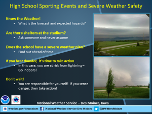
High School Sporting event safety during severe weather threats

News, Sports, Weather

October 4th, 2013 by Ric Hanson

1385958_530483693696497_1915631520_n

Special Weather Statement for Adair County

Weather

October 4th, 2013 by Ric Hanson

1249 PM CDT FRI OCT 4 2013

…SPECIAL WEATHER STATEMENT…

AT 1245 PM CDT…NATIONAL WEATHER SERVICE DOPPLER RADAR INDICATED A
STRONG THUNDERSTORM OVER SOUTH CENTRAL ADAIR COUNTY…MOVING
NORTHEAST AT 45 MPH.

ONE HALF INCH DIAMETER HAIL…WINDS GREATER THAN 30 MPH…ARE
POSSIBLE WITH THIS STORM. EXPECT THE STORM TO MOVE THROUGH
GREENFIELD AROUND 1 PM.

LOCATIONS IMPACTED INCLUDE…
GREENFIELD…         ADAIR…              STUART…

GUSTY WINDS MAY CAUSE SMALL OBJECTS SUCH AS TRASH BINS TO BLOW
AROUND. SEEK SHELTER IN A STURDY STRUCTURE UNTIL THIS STORM HAS
PASSED.

Local Football Game Times Changed Due to Weather Threat (Updated)

Sports

October 4th, 2013 by Jim Field

The Atlantic Varsity Football game at ADM will be played at 5:30 pm tonight.  The Atlantic Freshman Football game at ADM has been postponed to Monday time is TBD.  We will change our broadcast schedule as well.  “Who’s Gonna Win?” will now air at 4:30 pm, followed by our pre-game show at 5:00 pm.  Kick-off is at 5:30 pm.

The Harlan Community School District has announced the start time for the football game this evening (Oct. 4th) has been bumped up. Athletic Director Mitch Osborn says due to the weather related conditions, the Harlan Community Cyclone Homecoming game vs. Creston will start at 6pm. The gates will open at 4:30.

The Exira/EHK Homecoming football game tonight vs. Coon Rapids-Bayard at Exira has been changed.  Kick-off is now scheduled for 6:00 pm.

Tornadoes threat increasing across western IA today

News, Weather

October 4th, 2013 by Ric Hanson

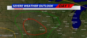
THE NATIONAL WEATHER SERVICE IN DES MOINES SAYS TORNADOES ARE POSSIBLE BY LATE AFTERNOON AND EARLY THIS EVENING IN THE KJAN LISTENING AREA.

Iowa Storm Chasing Network graphic of Tornadic/Severe Storm threat.

Iowa Storm Chasing Network graphic of Tornadic/Severe Storm threat.

IN THEIR HAZARDOUS WEATHER OUTLOOK ISSUED AT AROUND 12:10-P.M., THE WEATHER SERVICE SAID THERE IS A MODERATE RISK FOR SEVERE WEATHER LATE THIS AFTERNOON THROUGH THE EVENING.

ISOLATED THUNDERSTORMS ARE POSSIBLE THIS AFTERNOON WITH QUARTER SIZED HAIL AND 60 MPH WINDS POSSIBLE. MORE SIGNIFICANT SEVERE STORMS ARE THEN POSSIBLE LATER TODAY DURING THE MODERATE RISK TIME FRAME. VERY LARGE HAIL…GOLF BALL SIZED OR LARGER…70 MPH WINDS AND TORNADOES ARE ALL POSSIBLE. A STRONG TORNADO MAY OCCUR.

A moderate threat of severe weather, including tornadoes, remains in place for later this afternoon and this evening. The threat has shifted slightly to the south and west toward the Missouri River as well. Large hail, damaging winds, locally heavy rains and tornadoes are all possible. Some tornadoes may be strong and long lived.

Folks with early weekend activities, including high school football games, should monitor the weather closely. Have severe weather action plans in place beforehand being ready to seek shelter on short notice.

4 Pacific Junction men arrested for Possession of Stolen Property

News

October 4th, 2013 by Ric Hanson

The Mills County Sheriff’s Department reports four men were arrested Wednesday on Possession of Stolen Property/Theft in the 1st degree, and two counts each of Possession of Stolen Property/Theft in the 2nd degree. The men, all of whom are from Pacific Junction, were identified as: 19-year old Bragun Michael Michaelsen, 33-year old Timothy Eugene Truhlicka, 31-year old Jason Richard Marasco, and 34-year old Adam Michael Michaelsen.

Bragun Michaelsen was arrested at the Mills County Sheriff’s Office, while the other suspects were taken into custody at a location on Depot Street in Pacific Junction. Each was being held in the Mills County Jail on $20,000 bond.

Officials report also, the arrest on Thursday (Oct. 4th), of 49-year old Jack William Yost, of Shenandoah,  on charges of OWI/1st offense and Open Container. His bond was set at $1,465.  Earlier that same day, 19-year old Robert James Bailey, of Omaha, NE, was arrested in Washington County, NE, on a Warrant for Probation Violation. His bond was set at $10,000.

Hazardous Weather Outlook (Updated for western IA)

News, Weather

October 4th, 2013 by Ric Hanson

1153 AM CDT FRI OCT 4 2013
COUNTIES: MONONA-HARRISON-SHELBY-POTTAWATTAMIE-MILLS-MONTGOMERY-FREMONT-PAGE

THIS AFTERNOON AND TONIGHT….

THERE IS A MODERATE RISK FOR SEVERE THUNDERSTORMS OVER PARTS OF EXTREME EASTERN NEBRASKA AND WESTERN IOWA. THERE IS A SLIGHT RISK FOR SEVERE THUNDERSTORMS ACROSS THE REST OF THE OUTLOOK AREA.

THUNDERSTORMS ARE EXPECTED TO INITIALLY DEVELOP IN EASTERN NEBRASKA AFTER 3 PM. THESE THUNDERSTORMS WILL MOVE ACROSS EASTERN NEBRASKA AND INTO WESTERN IOWA THROUGH 7 PM. THE MAIN THREATS INITIALLY FROM THE THUNDERSTORMS WILL BE VERY LARGE HAIL AND DAMAGING WINDS. AS THE LINE OF STORMS PUSHES TOWARD THE MISSOURI RIVER STRONGER INSTABILITY AND WIND SHEAR WILL ENHANCE STORM DEVELOPMENT WITH THE  POTENTIAL FOR TORNADO DEVELOPMENT FOR AREAS ALONG THE MISSOURI RIVER INTO WESTERN IOWA.

THE STORMS ARE EXPECTED TO BE FAST MOVING AND PUSH EAST OUT OF THE AREA AFTER 9 PM.