

w/ Jim Field

Podcast: Play in new window | Download (7.1MB)
Subscribe: RSS

The Atlantic Area Chamber Ambassadors recently welcomed a new business, the Atlantic Collision Center, with a ribbon cutting at their location at 108 Cedar Street.
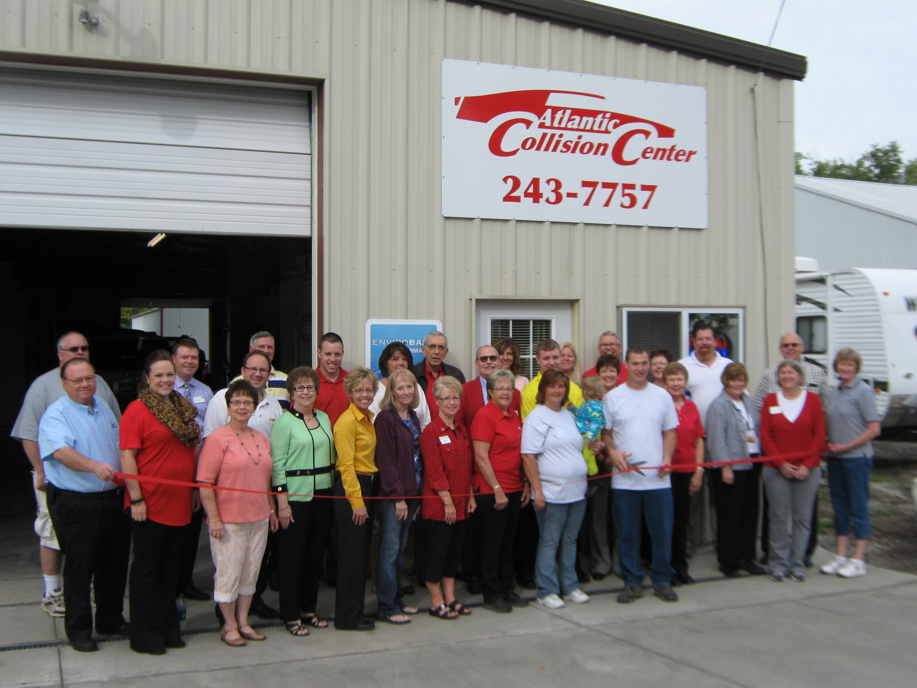
Pictured are Gerald Brink, Erika Govig, Connie Wailes, Nedra Perry, Becky Mosier, Kathie Hockenberry, Sue Muri, Janet Cappel, Pam Towne (and granddaughter Oakley), Doug Towne, Joanne Mueller, JoAnn Runyan, Dolly Bergmann, Kristi Ladd, Chris Neal, Jay Mendlik, Bill Saluk, Loran Coder, Lucas Mosier, Cindy Humphrey, Karl Aldag, Rich Perry, Diane Harris, Tyler Mosier, Tammy Waters, Carole Schuler, Keith Leonard, Arlene Drennan, Steve Andersen and Jeff Nelson. (Chamber photo)
Owners Doug and Pam Towne opened the beginning of August and specialize in auto body collision repair and restoration on a variety of vehicles including cars, trucks, golf carts, motorcycles and tractors with 25 years of experience. They are PPG certified and also work with all insurance companies.
Girls Class A Team Scores:
Abby Kohut-Jackson of Ballard was the champ. Atlantic’s Tiffany Williams was fourth and Savannah Sorensen was 17th.
Girls Class B Team Scores:
Destiny Scar of Nodaway Valley was the champion.
Boys Class A Team Scores:
Albert Meier of Boone won the race. Atlantic’s Josiah Williams was 24th.
Boys Class B Team Scores:
Trey Thompson of Ogden was first, Brayten Funke of Nodaway Valley was second, Shane Breheny of Nodaway Valley was fourth, Heath Downing of Nodaway Valley was tenth.
Girls Team Scores:
Girls Individuals:
Boys Team Scores:
Boys Individuals:
Police in Red Oak say a local man was arrested Thursday night on alcohol and other charges. 41-year-old Michael Scott Jones, of Red Oak, faces 2nd offense OWI and open container of alcohol charges, along with being cited for failure to display a registration plate and no proof of insurance.
Jones was being held in the Montgomery County Jail on $2,000 bond.
COUNTIES: SAC-CRAWFORD-CARROLL-AUDUBON-GUTHRIE-DALLAS
THERE IS A MODERATE RISK FOR SEVERE WEATHER LATE THIS AFTERNOON
AND THROUGH THE EVENING. ISOLATED THUNDERSTORMS ARE POSSIBLE THIS
MORNING THROUGH MID AFTERNOON WITH QUARTER SIZED HAIL AND 60 MPH
WINDS POSSIBLE. SIGNIFICANT SEVERE STORMS ARE POSSIBLE LATER TODAY
DURING THE MODERATE RISK TIME FRAME. VERY LARGE HAIL GOLF BALL
SIZED OR LARGER…70 MPH WINDS AND A FEW TORNADOES ARE ALL
POSSIBLE. A STRONG TORNADO MAY OCCUR.
SPOTTER ACTIVATION IS LIKELY FROM 3 PM TO MIDNIGHT TODAY.
COUNTIES: CASS-ADAIR-MADISON-ADAMS-UNION-TAYLOR-RINGGOLD–
ISOLATED SEVERE THUNDERSTORMS ARE POSSIBLE THROUGH MID AFTERNOON
TODAY WITH QUARTER SIZED HAIL AND 60 MPH WINDS. A GREATER RISK FOR
SEVERE WEATHER IS EXPECTED AFTER 5 PM THROUGH MIDNIGHT AS A LINE
OF STORMS DEVELOP OVER WESTERN IOWA AND RACE EAST THROUGH THE
EVENING. HALF DOLLAR SIZED HAIL…65 MPH WINDS AND AN ISOLATED
TORNADO OR TWO MAY OCCUR WITH THIS ACTIVITY.
SPOTTER ACTIVATION IS LIKELY BETWEEN 5 PM AND MIDNIGHT.
The National Weather Service says a moderate risk for severe weather is in place across northern Iowa this afternoon and evening while a slight risk encompasses much of the remainder of the state. Scattered thunderstorms will linger across the area this morning. An isolated severe storm with quarter sized hail and 60 mph winds are possible with this activity. A line of strong to severe storms is expected to develop over western Iowa by this afternoon.
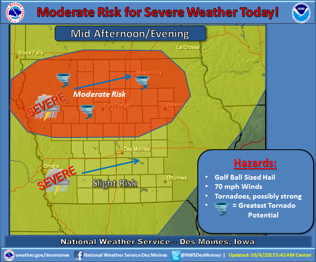
(Graphic) – NWS Severe Weather potential.
That activity will race northeast and into the area from late afternoon through mid-evening. Very large hail, damaging winds and a few tornadoes are likely, especially over the moderate risk region. A few severe storms with a heightened risk for damaging winds are likely over central and northern Iowa along with an attendant large hail and isolated tornado threat. This could become a potentially dangerous situation.
Be prepared to take appropriate actions if severe weather approaches your location. The storms will begin to weaken after midnight. By Saturday, a strong cold front will be passing through the area, ushering in much colder temperatures. Thunderstorm chances will pass to the east with dry and windy conditions in place by the afternoon.
COUNTIES: MONONA-HARRISON-SHELBY-POTTAWATTAMIE-MILLS-MONTGOMERY-FREMONT-PAGE-
THERE IS A MODERATE RISK FOR SEVERE THUNDERSTORMS OVER PARTS OF WEST CENTRAL IOWA, TODAY. THERE IS A SLIGHT RISK FOR SEVERE THUNDERSTORMS ACROSS THE REST OF THE OUTLOOK AREA.
THUNDERSTORMS ARE EXPECTED TO INITIALLY DEVELOP IN NORTHEAST
NEBRASKA NEAR AND AFTER 2 PM. THESE THUNDERSTORMS WILL MOVE ACROSS NORTHEAST NEBRASKA AND INTO WEST CENTRAL IOWA THROUGH 7 PM. THE MAIN THREATS FROM THESE THUNDERSTORMS WILL BE VERY LARGE
HAIL…SOME GREATER THAN 2 INCHES IN DIAMETER…STRONG WIND GUSTS
AND TORNADOES.
OTHER THUNDERSTORMS ARE EXPECTED TO DEVELOP ALONG AND EAST OF A
LINE FROM NEAR FREMONT, NE, TO BEATRICE, NE. THESE THUNDERSTORMS WILL LIKELY DEVELOP AFTER 4 PM AND MOVE EAST THROUGH EAST CENTRAL AND SOUTHEAST NEBRASKA BY 7 PM…AND ACROSS SOUTHWEST IOWA THROUGH 10 PM. LARGE HAIL…DAMAGING WINDS AND ISOLATED TORNADOES WILL BE POSSIBLE WITH THIS ACTIVITY.
Here are some reported rainfall amounts from the storms which fell from late Thursday afternoon through early this (Friday) morning (7-a.m.):
The Valley (Hwy 71/I-80 area in Cass County), 3.00″; Atlantic (KJAN), 2.12” (24-hour total…2.2″ as of 8-a.m.); Massena, 1.71″; Oakland, 2.00″; Audubon, .55″; a location south of Avoca, 2.87″; Emerson, .92″; Shenandoah, .23″, Red Oak, .90″, 3 1/4 miles south of Elk Horn received 3.8″, northeast of Atlantic 3.24″ of rain; 4-miles east of Council Bluffs, 2.44″.
If you have a rainfall amount you would like to report, call us at 1-800-283-5526, or e-mail: kjannews@metc.net. Please be sure and tell us where you’re from, the time you measured the rain and any other significant weather observations (Hail, damage, etc.). Thank You!

