712 Digital Group - top

Updated NWS Forecast for Cass & Area Counties

Weather

May 10th, 2014 by Ric Hanson

246 PM CDT SAT MAY 10 2014
**Severe Thunderstorm Watch until 10-p.m. for Adams, Fremont, Mills, Mongtomery, Page, Ringgold Taylor and Union Counties**
LATE THIS AFTERNOON…PARTLY SUNNY WITH SCATTERED THUNDERSTORMS. BREEZY. SOUTH WIND 15 TO 20 MPH. CHANCE OF THUNDERSTORMS 40 PERCENT.

TONIGHT…MOSTLY CLOUDY THEN BECOMING PARTLY CLOUDY BEFORE MIDNIGHT AND EARLY MORNING THEN BECOMING MOSTLY CLOUDY. SCATTERED THUNDERSTORMS IN THE EVENING…THEN ISOLATED THUNDERSTORMS BEFORE MIDNIGHT. SCATTERED THUNDERSTORMS EARLY IN THE MORNING. LOW IN THE MID 50S. SOUTHEAST WIND NEAR 10 MPH. CHANCE OF THUNDERSTORMS 50 PERCENT.

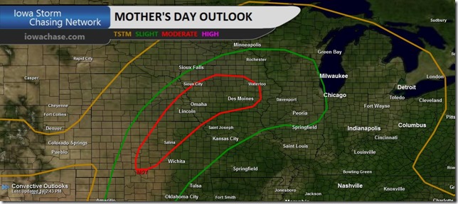
SUNDAY…THUNDERSTORMS UNTIL LATE AFTERNOON…THEN THUNDERSTORMS LIKELY LATE IN THE AFTERNOON. BREEZY. SOME THUNDERSTORMS MAY BE SEVERE WITH HEAVY RAINFALL LATE IN THE AFTERNOON. HIGH IN THE UPPER 70S. SOUTHEAST WIND 10 TO 20 MPH. CHANCE OF THUNDERSTORMS 80 PERCENT.

SUNDAY NIGHT…THUNDERSTORMS. SOME THUNDERSTORMS MAY BE SEVERE WITH HEAVY RAINFALL…THEN SOME THUNDERSTORMS MAY PRODUCE HEAVY RAINFALL AFTER MIDNIGHT. LOW IN THE UPPER 50S. NORTHEAST WIND 5 TO 15 MPH WITH GUSTS TO AROUND 30 MPH SHIFTING TO THE SOUTH AFTER MIDNIGHT. CHANCE OF THUNDERSTORMS NEAR 100 PERCENT.

MONDAY…SHOWERS LIKELY AND ISOLATED THUNDERSTORMS. COOLER. HIGH IN THE MID 60S. NORTHWEST WIND NEAR 10 MPH INCREASING TO 10 TO 15 MPH WITH GUSTS TO AROUND 25 MPH IN THE AFTERNOON. CHANCE OF PRECIPITATION 60 PERCENT.

MONDAY NIGHT…MOSTLY CLOUDY WITH A SLIGHT CHANCE OF SHOWERS AND ISOLATED THUNDERSTORMS THROUGH MIDNIGHT…THEN PARTLY CLOUDY AFTER MIDNIGHT. COLDER. LOW IN THE LOWER 40S. NORTHWEST WIND 5 TO 15 MPH. CHANCE OF PRECIPITATION 20 PERCENT.

TUESDAY AND TUESDAY NIGHT…PARTLY CLOUDY. BREEZY. HIGH IN THE UPPER 50S. LOW IN THE LOWER 40S.

Severe Thunderstorm Warning: East Pottawattamie County

Weather

May 10th, 2014 by Ric Hanson

BULLETIN – IMMEDIATE BROADCAST REQUESTED
SEVERE THUNDERSTORM WARNING
NATIONAL WEATHER SERVICE OMAHA/VALLEY NEBRASKA
248 PM CDT SAT MAY 10 2014

THE NATIONAL WEATHER SERVICE IN OMAHA HAS ISSUED A

* SEVERE THUNDERSTORM WARNING FOR…
EASTERN POTTAWATTAMIE COUNTY IN SOUTHWEST IOWA…

* UNTIL 315 PM CDT

* AT 248 PM CDT…A SEVERE THUNDERSTORM WAS LOCATED NEAR OAKLAND…OR
14 MILES WEST OF ATLANTIC…MOVING NORTHEAST AT 30 MPH.

HAZARD…QUARTER SIZE HAIL.

SOURCE…RADAR INDICATED.

IMPACT…DAMAGE TO VEHICLES IS EXPECTED.

* LOCATIONS IMPACTED INCLUDE…
OAKLAND…WALNUT…HANCOCK…FARM CREEK PUBLIC WILDLIFE AREA AND
BOTNA BEND PARK.

THIS INCLUDES THE FOLLOWING HIGHWAYS…
HIGHWAY 59 IN IOWA BETWEEN MILE MARKERS 52 AND 58 .
INTERSTATE 80 IN IOWA NEAR MILE MARKER 48.

PRECAUTIONARY/PREPAREDNESS ACTIONS…

FOR YOUR PROTECTION MOVE TO AN INTERIOR ROOM ON THE LOWEST FLOOR OF A
BUILDING.

Severe Thunderstorm Watch for southern/sw Iowa until 10-pm Sat.

Weather

May 10th, 2014 by Ric Hanson

NWS STORM PREDICTION CENTER NORMAN OK

230 PM CDT SAT MAY 10 2014

SEVERE THUNDERSTORM WATCH 137 IS IN EFFECT UNTIL 10:00 PM CDT FOR THE FOLLOWING LOCATIONS…. IOWA COUNTIES INCLUDED ARE

ADAMS DECATUR FREMONT MILLS MONTGOMERY PAGE RINGGOLD TAYLOR UNION

PRIMARY THREATS INCLUDE SCATTERED LARGE HAIL LIKELY WITH ISOLATED VERY LARGE HAIL EVENTS TO 3 INCHES IN DIAMETER POSSIBLE ISOLATED DAMAGING WIND GUSTS TO 70 MPH POSSIBLE A TORNADO OR TWO POSSIBLE.

THE SEVERE THUNDERSTORM WATCH AREA IS APPROXIMATELY ALONG AND 60 STATUTE MILES EAST AND WEST OF A LINE FROM 45 MILES SOUTH OF CHANUTE KANSAS TO 40 MILES EAST NORTHEAST OF SHENANDOAH IOWA.

PRECAUTIONARY/PREPAREDNESS ACTIONS…

REMEMBER…A SEVERE THUNDERSTORM WATCH MEANS CONDITIONS ARE FAVORABLE FOR SEVERE THUNDERSTORMS IN AND CLOSE TO THE WATCH AREA. PERSONS IN THESE AREAS SHOULD BE ON THE LOOKOUT FOR THREATENING WEATHER CONDITIONS AND LISTEN FOR LATER STATEMENTS AND POSSIBLE WARNINGS. SEVERE THUNDERSTORMS CAN AND OCCASIONALLY DO PRODUCE TORNADOES.

Supercell thunderstorms and long-track tornadoes possible Sunday

News, Weather

May 10th, 2014 by Ric Hanson

Meteorologists are warning residents of the Midwest to stay pay close attention to the forecast for Mother’s Day. The Severe Storms Prediction Center in Norman, OK., says a severe weather outbreak with many tornadoes and very large hail is possible Sunday and Sunday night across parts of the central plains and mid-Missouri valley. Persons celebrating with loved ones and those attending graduations should be aware of a potentially explosive outbreak of severe weather. Much if Iowa, especially southwest and west central parts of the state, fall under the “Moderate” risk category.day-2_thumb

Officials with the Iowa Storm Chasing Network say “Of particular concern here in Iowa is the conditions which will favor the development of a few, independent supercells, rather than a more linear bowing structure of storms.  This setup gives us concern that not only are tornadoes possible, but strong, long-track tornadoes as well.”

www.weather.gov/desmoines

Chiefs take RB De’Anthony Thomas in 4th round

Sports

May 10th, 2014 by Ric Hanson

KANSAS CITY, Mo. (AP) — The Chiefs selected Oregon running back De’Anthony Thomas with their fourth-round pick Saturday, finally addressing the offense after spending their first two picks on defense. Thomas fits what coach Andy Reid likes in a running back. He possesses exceptional speed and quickness, and can catch the ball out of the backfield or line up as a wide receiver. He should be a replacement for departed wide receiver Dexter McCluster.

The Chiefs already have Pro Bowl running back Jamaal Charles and bruising Knile Davis on the roster. Davis was a third-round pick a year ago. The Chiefs picked Auburn defensive end Dee Ford in the first round Thursday night. They went with cornerback Phillip Gaines out of Rice with their lone pick on Friday.

(Podcast) 7:06-a.m. Area/State News & funeral report, 5/10/2014

News, Podcasts

May 10th, 2014 by Ric Hanson

With KJAN News Director Ric Hanson.

Play

(Podcast) 7:18-a.m. Sports, 5/10/2014

Podcasts, Sports

May 10th, 2014 by Ric Hanson

With KJAN News Director Ric Hanson.

Play

Audubon City Council to hold hearing on meeting time & dates

News

May 10th, 2014 by Ric Hanson

The Audubon City Council will meet Monday evening to take care of some administrative matters. Among the items on their agenda, is a Public Hearing on an Ordinance amending the City’s Code of Ordinances, with regard to the date and time of future City Council meetings. The amendment proposes changing the time to 5:30-p.m. instead of 7-p.m., and from the second and fourth Mondays of each month to the third Wednesday of the month. The hearing will be followed by a roll call vote on the first reading of the amended Ordinance.

The Council will also discuss and vote on a Resolution ordering the acquisition or condemnation, if necessary, of 408 Market Street, which is an old gas station. The hope is that the City can negotiate a purchase price for property not to exceed $10,000, so that the site may be cleaned up using state assistance.

In other business, the Council will act on appointing Jan Roberts as Deputy City Clerk and the appointment of Shelly Burr to the Board of Adjustment. The meeting begins at 7-p.m. Monday, at the Audubon City Hall.

(Podcast) Skyscan Forecast: Sat., May 10th 2014

Podcasts, Weather

May 10th, 2014 by Ric Hanson

Here’s the weather forecast for Atlantic and the KJAN listening area, and weather information for Atlantic.

Play

Hazardous Weather Outlook for west central/Iowa: 5/10/14

Weather

May 10th, 2014 by Ric Hanson

AREA COUNTIES: SAC-CRAWFORD-CARROLL-AUDUBON-GUTHRIE-DALLAS-CASS-ADAIR-MADISON-ADAMS-UNION-TAYLOR-RINGGOLD
455 AM CDT SAT MAY 10 2014

TODAY AND TONIGHT:
A SLIGHT RISK OF SEVERE THUNDERSTORMS IS FORECAST OVER SOUTHERN IOWA…GENERALLY ALONG AND SOUTH OF HIGHWAY 34…THIS AFTERNOON AND EVENING. LARGE HAIL AND DAMAGING WINDS ARE THE MAIN THREAT. ISOLATED STRONG TO POTENTIALLY SEVERE THUNDERSTORMS LOOK POSSIBLE NORTH OF HIGHWAY 34…WHERE HAIL AND WINDS REMAIN A THREAT.

SUNDAY:
THE PROBABILITY FOR WIDESPREAD SEVERE THUNDERSTORMS IS INCREASING SUNDAY INTO SUNDAY EVENING. LARGE HAIL AND ISOLATED TORNADOES WILL BE POSSIBLE OVER MUCH OF CENTRAL IOWA. HEAVY RAIN IS ALSO ANTICIPATED SUNDAY AFTERNOON THROUGH MONDAY AND MAY LEAD TO LOCALIZED AREAS OF FLASH FLOODING.

SPOTTER INFORMATION STATEMENT…
SPOTTER ACTIVATION IS POSSIBLE THIS AFTERNOON AND EVENING…AND WILL LIKELY BE NEEDED SUNDAY INTO SUNDAY NIGHT…AND AGAIN ON MONDAY.