United Group Insurance

Macedonia chopper crash update

News

September 8th, 2014 by Ric Hanson

Sheriff’s officials in Pottawattamie County have released additional details about a crop dusting helicopter crash that happened Saturday afternoon, south of Macedonia. Authorities identified the pilot as 26-year-old Christopher Moore, of Creston.

Moore was flying over a soybean field when his helicopter hit a non-energized power line just south of Pioneer Trail and 340th Street. Treynor Fire Chief Russ Maguire said Moore was outside the wreckage and conscious when paramedics arrived on the scene. He was transported to Creighton University Medical Center in Omaha for treatment for non-life threatening injuries.

Officials with the FAA were contacted and were expected to investigate the crash.

Creston man arrested for assault on a police officer

News

September 8th, 2014 by Ric Hanson

Police in Creston report 23-year old Christopher Gage Cosenza, of Creston, was arrested early Saturday morning. Cosenza was taken into custody at around 2-a.m. on charges that include Assault on a Police Officer with Injury, Domestic Assault, and Assault with Injury. He was being held in the Union County Jail on $2,000 bond.

Last Friday afternoon, Daniel James Perkins, of Creston, was arrested at the Union County Jail, for Violation of a Protective Order. Perkins remained in the jail on $300 bond.

And, a Clarinda woman reported to Creston Police her vehicle was vandalized while it was parked at the Intersection of New York Avenue and Patriotic Parkway, in Creston. The damage was estimated at $3,000.

Significant Weather Advisory: Monona County, IA

Weather

September 8th, 2014 by Ric Hanson

MONONA IA-
817 AM CDT MON SEP 8 2014

…SIGNIFICANT WEATHER ADVISORY FOR MONONA COUNTY UNTIL 900 AM CDT…

AT 814 AM CDT…DOPPLER RADAR WAS TRACKING A STRONG THUNDERSTORM NEAR
SMITHLAND…OR 28 MILES SOUTHWEST OF IDA GROVE…MOVING SOUTHEAST AT
35 MPH.

WIND GUSTS UP TO 50 MPH WILL BE POSSIBLE WITH THIS STORM.

LOCATIONS IMPACTED INCLUDE…
ONAWA…WHITING…UTE…MAPLETON…SOLDIER…CASTANA…TURIN…
RODNEY…KENNEBEC AND LEWIS AND CLARK STATE PARK.

(Podcast) 8-a.m. Area/State News, 09/08/2014

News, Podcasts

September 8th, 2014 by Ric Hanson

With KJAN News Director Ric Hanson.

Play

Heartbeat Today 09-08-2014

Heartbeat Today, Podcasts

September 8th, 2014 by admin

Jim Field speaks with Dave Hancock about the Wiota All-School Alumni Reunion.

Play

(Podcast) 7:20-a.m. Sports, 09/08/2014

Podcasts, Sports

September 8th, 2014 by Ric Hanson

With KJAN Sports Director Jim Field.

Play

(Podcast) 7:07-a.m. News & funeral report, Mon. 9/8/2014

News, Podcasts

September 8th, 2014 by Ric Hanson

With KJAN News Director Ric Hanson.

Play

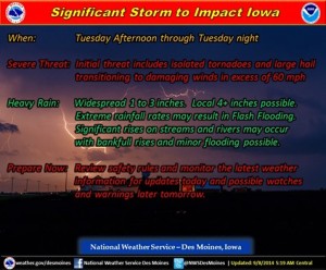
Significant storm to impact Iowa late Tuesday

News, Weather

September 8th, 2014 by Ric Hanson

The National Weather Service in Des Moines says a significant storm will impact Iowa by late Tuesday into Tuesday night. Before then, scattered thunderstorms are possible today through Tuesday morning. A few severe storms may develop with this initial activity. The primary system arrives over western Iowa by late Tuesday afternoon.

Severe storm outlook (NWS/Des Moines)

Severe storm outlook (NWS/Des Moines)

Severe storms are becoming more likely – especially late Tuesday afternoon through mid-evening with tornadoes, large hail and damaging winds all possible. In addition, a significant heavy rainfall event is expected and may result in localized flash flooding and significant rises on area streams and some rivers.

Much colder air will follow the storm by Thursday night. Early morning lows Friday and Saturday are forecast to dip into the 30s in some areas. Highs will only reach the 50s to lower 60s both Thursday and Friday.

Western/SW IA Hazardous Weather Outlook: 9/8/14

Weather

September 8th, 2014 by Ric Hanson

AREA COUNTIES: SAC-CRAWFORD-CARROLL-AUDUBON-GUTHRIE-DALLAS-CASS-ADAIR-MADISON-ADAMS-UNION-TAYLOR-RINGGOLD-
531 AM CDT MON SEP 8 2014

TODAY AND TONIGHT….NON SEVERE THUNDERSTORMS WILL SPREAD ACROSS THE AREA TODAY THROUGH THE AFTERNOON. ANOTHER ROUND OF THUNDERSTORMS IS LIKELY DURING
THE EVENING AND OVERNIGHT TONIGHT. A FEW STORMS MAY BE SEVERE WITH LARGE HAIL AND WIND BEING THE MAIN THREATS.

TUESDAY AND WEDNESDAY….A SIGNIFICANT STORM WILL AFFECT THE AREA TUESDAY AFTERNOON THROUGH EARLY WEDNESDAY MORNING. A FEW MAINLY NON SEVERE THUNDERSTORMS WILL BE POSSIBLE TUESDAY MORNING THROUGH EARLY AFTERNOON.

THUNDERSTORMS ARE LIKELY LATE TUESDAY AFTERNOON AND TUESDAY NIGHT. SEVERE THUNDERSTORMS WITH HEAVY RAINFALL…DAMAGING WINDS…TORNADOES AND A LESSER THREAT FOR LARGE HAIL WILL BE POSSIBLE IN THE LATE AFTERNOON THROUGH MID EVENING. LATE IN THE EVENING OR TUESDAY NIGHT DAMAGING WINDS AND HEAVY RAINFALL WILL BE
THE MAIN THREATS ACROSS MUCH OF THE AREA. THERE IS A POTENTIAL FOR FLASH FLOODING DUE TO HIGH RAINFALL RATES AND SOME RIVERS OR STREAMS MAY REACH BANKFULL OR PRODUCE MINOR FLOODING.

SPOTTER INFORMATION STATEMENT…

SPOTTER ACTIVATION WILL LIKELY BE NEEDED TUESDAY AFTERNOON AND EVENING OVER PORTIONS OF THE OUTLOOK AREA.

AREA COUNTIES: MONONA-HARRISON-SHELBY-POTTAWATTAMIE-MILLS-MONTGOMERY-FREMONT-PAGE

TODAY AND TONIGHT…A FEW THUNDERSTORMS ARE EXPECTED IN NORTHEAST NEBRASKA AND MAYBE WEST CENTRAL IOWA THIS MORNING. A FEW OF THESE STORMS COULD CONTAIN HAIL AND WERE DRIVEN BY AN UPPER LEVEL DISTURBANCE AND ASSOCIATED LOW LEVEL JET.

ADDITIONAL THUNDERSTORMS COULD DEVELOP OR MOVE INTO THE REGION TONIGHT…MAINLY AFTER MIDNIGHT…AS ANOTHER DISTURBANCE APPROACHES. SEVERE WEATHER WITH THESE STORMS IS UNLIKELY.

TUESDAY AND WEDNESDAY…THUNDERSTORMS ARE EXPECTED TO BECOME MORE WIDESPREAD OVER THE AREA TUESDAY AND TUESDAY EVENING AS MOISTURE AND INSTABILITY INCREASES ACROSS THE PLAINS AND A DISTURBANCE SENDS A COLD FRONT
INTO NEBRASKA. SEVERE THUNDERSTORMS ARE POSSIBLE…MAINLY FROM LATE TUESDAY AFTERNOON THROUGH TUESDAY EVENING…WITH DAMAGING WINDS AND LARGE HAIL PRIMARY HAZARDS ALONG WITH LOCALLY HEAVY RAIN. IN ADDITION…A SMALL WINDOW COULD EXIST FROM LATE AFTERNOON THROUGH MID EVENING FOR TORNADOES IF CONVECTIVE DEBRIS DOES NOT BECOME TOO WIDESPREAD ALLOWING MORE ISOLATED STORMS ALONG A POSSIBLE WARM FRONT IN SOUTHEAST OR EAST CENTRAL NEBRASKA AND
SOUTHWEST IOWA.

(Podcast) Skyscan Forecast: Mon., Sept. 8 2014

Podcasts, Weather

September 8th, 2014 by Ric Hanson

The Freese-Notis weather forecast for the KJAN listening area and weather info. for Atlantic.

Play