712 Digital Group - top

Severe weather possible again today, along with heavy rain

News, Weather

June 30th, 2014 by Ric Hanson

The National Weather Service in Des Moines says will be the potential for more severe weather today, including tornadoes, strong thunderstorm winds and large hail. There will also be the potential for locally heavy rainfall. Today may also bring a widespread significant wind event to the area in the late morning or afternoon.10300175_665261853552013_8036064793642513688_n A Severe Thunderstorm Watch is in effect for the entire KJAN listening area until Noon today. And, a Flash Flood Watch is in effect until 2-p.m. for the Monona, Harrison, Shelby and Pottawattamie Counties. A Flash Flood Watch is in effect until 6-p.m. for the rest of the KJAN listening area.
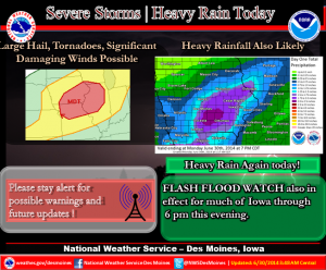
Be prepared for dangerous storms that approach your area…stay alert to changing conditions and monitor your NOAA weather radio for forecast updates and possible watches and warnings. Review your severe weather safety procedures and move promptly to a place of safety if a warning is issued for your area.

Storms that developed Sunday afternoon in eastern Nebraska crossed into western Iowa’s Harrison County before spreading east through Shelby and Audubon Counties late into the evening, and then into central Iowa. The storms affecting our area dropped hail ranging in size from quarters in most locations, to baseball-sized hail near Magnolia.

There were also reports of funnel clouds in and around the Harlan and Elk Horn areas late Sunday evening, and one possible touchdown of a tornado in a rural area northwest of Harlan, but there were no immediate reports of damage.

Update: Flash Flood Watch extended until this afternoon for western/central Iowa

Weather

June 30th, 2014 by Ric Hanson

AREA COUNTIES: SAC-CRAWFORD-CARROLL-AUDUBON-GUTHRIE-DALLAS-CASS-ADAIR-MADISON-ADAMS-UNION-TAYLOR-RINGGOLD-

343 AM CDT MON JUN 30 2014

FLASH FLOOD WATCH NOW IN EFFECT THROUGH 6-P.M. TODAY (MONDAY)

* THUNDERSTORMS CAPABLE OF HEAVY RAINFALL WILL CONTINUE TO DEVELOP AND TRACK ACROSS MUCH OF IOWA…OVER AREAS WHICH HAVE RECENTLY RECEIVED SEVERAL INCHES OF RAINFALL. ALREADY MOIST SOILS COMBINED WITH ADDITIONAL HEAVY RAINFALL OF 1 TO TWO INCHES…AND LOCAL HIGHER AMOUNTS…MAY LEAD TO AREAS OF FLASH FLOODING TODAY.

* MOST FLASH FLOOD DEATHS OCCUR IN VEHICLES. USE CAUTION WHILE TRAVELING. DO NOT DRIVE THROUGH FLOODED ROADWAYS…TURN AROUND DO NOT DROWN.

PRECAUTIONARY/PREPAREDNESS ACTIONS…

A FLASH FLOOD WATCH MEANS THAT CONDITIONS MAY DEVELOP THAT LEAD TO FLASH FLOODING. FLASH FLOODING IS A VERY DANGEROUS SITUATION. YOU SHOULD MONITOR LATER FORECASTS AND BE PREPARED TO TAKE ACTION SHOULD FLASH FLOOD WARNINGS BE ISSUED.


Numerous vehicle burglaries reported in Hamburg

News

June 30th, 2014 by Ric Hanson

Authorities in Fremont County are asking for your help in solving numerous burglaries that occurred in the Hamburg area early Sunday morning. The Fremont County Sheriffs’ Office says it received nearly a dozen reports of vehicles being broken into. Officials say it appears in each case, those vehicles were not locked.

The Sheriff’s Office reminds citizens to lock their vehicles and not leave valuable items in plain view inside. If you see any suspicious activity, report it to law enforcement. Persons with information about the incidents in Hamburg are asked to call the Fremont County Sheriff’s Office, or Crime Stoppers at 712-374-2424.

Updated KJAN listening area forecast: Mon., June 30 2014

Weather

June 30th, 2014 by Ric Hanson

331 AM CDT MON JUN 30 2014

FLASH FLOOD WATCH IN EFFECT THROUGH THIS AFTERNOON

EARLY THIS MORNING…MOSTLY CLOUDY WITH ISOLATED THUNDERSTORMS. SOME THUNDERSTORMS MAY BE SEVERE. SOUTHWEST WIND NEAR 10 MPH. CHANCE OF THUNDERSTORMS 20 PERCENT.

TODAY...MOSTLY CLOUDY. ISOLATED THUNDERSTORMS THROUGH MID MORNING…THEN SCATTERED THUNDERSTORMS BEFORE NOON. NUMEROUS THUNDERSTORMS IN THE AFTERNOON. SOME THUNDERSTORMS MAY BE SEVERE…THEN SOME THUNDERSTORMS MAY BE SEVERE WITH DAMAGING WIND…LARGE HAIL AND HEAVY RAINFALL. HIGH IN THE LOWER 80S. SOUTHWEST WIND 5 TO 15 MPH. CHANCE OF THUNDERSTORMS 70 PERCENT.

TONIGHT…MOSTLY CLOUDY IN THE EVENING THEN CLEARING. SCATTERED THUNDERSTORMS IN THE EVENING. SOME THUNDERSTORMS MAY BE SEVERE WITH DAMAGING WIND…LARGE HAIL AND HEAVY RAINFALL. LOW IN THE LOWER 60S. WEST WIND 5 TO 15 MPH. CHANCE OF THUNDERSTORMS 50 PERCENT.

TUESDAY…MOSTLY SUNNY. A SLIGHT CHANCE OF SHOWERS AND ISOLATED THUNDERSTORMS IN THE AFTERNOON. BREEZY. HIGH IN THE UPPER 70S. WEST WIND 10 TO 20 MPH WITH GUSTS TO AROUND 30 MPH. CHANCE OF PRECIPITATION 20 PERCENT.

TUESDAY NIGHT AND WEDNESDAY…PARTLY CLOUDY. LOW IN THE MID 50S. HIGH 72 TO 79. NORTHWEST WIND 5 TO 15 MPH WITH GUSTS TO AROUND 25 MPH.

WEDNESDAY NIGHT THROUGH THURSDAY NIGHT...PARTLY CLOUDY. LOW IN THE UPPER 50S. HIGH IN THE MID 70S.

2 people from Oregon injured in Fremont Co. crash

News

June 30th, 2014 by Ric Hanson

Two Oregon residents were injured during a single-vehicle accident Saturday evening on Interstate 29 in Fremont County. The Iowa State Patrol reports a 2006 Acura driven by 30-year old Tuffy Kin Leung, of Portland, OR, was traveling south in the left lane of I-29 at around 6:55-p.m., when Leung became fatigued and closed his eyes.

After his car crossed the right lane and entered the right ditch, Leung tried to correct the vehicles’ course but lost control. The car rolled over and came to rest on its top, partially blocking the right lane of I-29. Leung, and his passenger, 29-year old Lisa Kim Chan, also from Portland, were able to get out of the vehicle on their own. They were transported by Hamburg and Percival Rescue to Grape Community Hospital in Hamburg.

DOT facial recognition software leads to more than 150 investigations each year

News

June 30th, 2014 by Ric Hanson

The discovery that a fugitive from North Carolina was living in Iowa came after software used by the Iowa Department of Transportation found the man had applied for two driver’s licenses. D-O-T director of Investigations and Identity theft, Paul Steier, says the software has been one of the best tools available to help prevent identity theft from Iowans. “We investigate an average of 125 to probably 175 cases a year that were based on our facial recognition results,” Steier says. “From there we have to actually work and investigation — we just don’t take those results and go to the court with them.”

While the recent case turned up a man who had been fleeing the law for 41 years, Steier says most cases are people trying to steal somebody’s identity for financial gain.  “When we issue a license, that image is stored, so if somebody else would try come in some day and try to obtain a license under your name or my name, that system should catch the fact that it’s not a match — it doesn’t match what’s on file, it’s not the same,” Steier says. “And hopefully it stops a fraud from occurring or somebody from getting an official state-issued document showing them as being somebody else than they really are.”

The system is one of the reasons why the D-O-T asks you not to give a big wide smile when they take your driver’s license picture. Neutral facial expression, that gives us the best result. So, in order to protect our identities, the best thing that we can have people do is give us a neutral facial expression — a minimal smile — and that way the system will have better results,” Steier says. The system was upgraded last fall and now gives investigators like Steier more options in dealing with the pictures.

“If we have a photograph of someone that’s not maybe the best photograph, we can actually take software and enhance that image and make it a better quality photograph. Because the better the quality of the image,the better the results of the facial recognition inquiry, and the better possibility for either a no match or a positive match,” Steier says. The D-O-T started using the facial recognition system in 2008, but has photos going back 13 years that the system can check.

(Radio Iowa)

Flash Flood Watch Continues until 7-am (6/30/14) for west central/central IA

Weather

June 30th, 2014 by Ric Hanson

AREA COUNTIES: SAC-CRAWFORD-CARROLL-AUDUBON-GUTHRIE-DALLAS-CASS-ADAIR-MADISON-ADAMS-UNION-TAYLOR-RINGGOLD….A FLASH FLOOD WATCH REMAINS IN EFFECT UNTIL 7 AM CDT.

FLASH FLOODING IS ESPECIALLY DANGEROUS AT NIGHT…AND MOST FLASH FLOOD DEATHS OCCUR IN VEHICLES. USE CAUTION WHILE TRAVELING…ESPECIALLY AT NIGHT. DO NOT DRIVE THROUGH FLOODED ROADWAYS…TURN AROUND DO NOT DROWN.

PRECAUTIONARY/PREPAREDNESS ACTIONS…

A FLASH FLOOD WATCH MEANS THAT CONDITIONS MAY DEVELOP THAT LEAD
TO FLASH FLOODING. FLASH FLOODING IS A VERY DANGEROUS SITUATION.

Flash Flood Watch update: Far west/southwest IA 6/30/2014

Weather

June 30th, 2014 by Ric Hanson

256 AM CDT MON JUN 30 2014

AREAS OF HEAVY RAIN LIKELY THIS MORNING….HEAVY RAIN PRODUCING THUNDERSTORMS WILL LIKELY INCREASE IN COVERAGE OVER THE AREA THIS MORNING BEFORE SHIFTING INTO IOWA AROUND OR SHORTLY AFTER MIDDAY. ALTHOUGH NOT EVERY LOCATION WILL RECEIVE HEAVY RAIN…LOCAL AMOUNTS IN EXCESS OF 2 INCHES ARE POSSIBLE. WITH THE GROUND NEARLY SATURATED OVER MUCH OF THE AREA.

AREA COUNTIES IN IOWA: MONONA-HARRISON-SHELBY-POTTAWATTAMIE: FLASH FLOOD WATCH IN EFFECT FROM 6 AM THIS MORNING TO 2 PM CDT THIS AFTERNOON.

* RECENT HEAVY RAINS HAVE NEARLY SATURATED THE SOIL MAKING RUNOFF  FROM HEAVIER RAIN MORE LIKELY. THIS COULD LEAD TO FLOODING OR FLASH FLOODING.

 PRECAUTIONARY/PREPAREDNESS ACTIONS… 

A FLASH FLOOD WATCH MEANS THAT CONDITIONS MAY DEVELOP THAT LEAD TO FLASH FLOODING. FLASH FLOODING IS A VERY DANGEROUS SITUATION. YOU SHOULD MONITOR LATER FORECASTS AND BE PREPARED TO TAKE ACTION SHOULD FLASH FLOOD WARNINGS BE ISSUED.

Shelby County Tornado Warning Cancelled

Weather

June 29th, 2014 by Ric Hanson

SHELBY IA-

829 PM CDT SUN JUN 29 2014

…THE TORNADO WARNING FOR CENTRAL SHELBY COUNTY IS CANCELLED…

THE STORM WHICH PROMPTED THE WARNING HAS WEAKENED BELOW SEVERE LIMITS…AND NO LONGER APPEARS CAPABLE OF PRODUCING A TORNADO. THEREFORE THE WARNING HAS BEEN CANCELLED.

A TORNADO WATCH REMAINS IN EFFECT UNTIL 1100 PM CDT SUNDAY FOR SOUTHWEST IOWA AND EASTERN NEBRASKA

Tornado Warning: Shelby County

Weather

June 29th, 2014 by Ric Hanson

809 PM CDT SUN JUN 29 2014

THE NATIONAL WEATHER SERVICE IN OMAHA HAS ISSUED A TORNADO WARNING FOR… WEST CENTRAL SHELBY COUNTY IN SOUTHWEST IOWA…UNTIL 845 PM CDT

* AT 808 PM CDT…A SEVERE THUNDERSTORM CAPABLE OF PRODUCING A TORNADO WAS LOCATED NEAR EARLING…OR 21 MILES SOUTH OF DENISON… MOVING EAST AT 30 MPH.

HAZARD…TORNADO.

SOURCE…RADAR INDICATED ROTATION.

IMPACT…FLYING DEBRIS WILL BE DANGEROUS TO THOSE CAUGHT WITHOUT SHELTER. MOBILE HOMES WILL BE DAMAGED OR DESTROYED. DAMAGE TO ROOFS…WINDOWS AND VEHICLES WILL OCCUR. TREE DAMAGE IS LIKELY.

* THIS TORNADIC THUNDERSTORM WILL REMAIN OVER MAINLY RURAL AREAS OF WEST CENTRAL SHELBY COUNTY…INCLUDING THE FOLLOWING LOCATIONS… PANAMA AND WESTPHALIA.

THIS INCLUDES HIGHWAY 59 IN IOWA BETWEEN MILE MARKERS 80 AND 83.

PRECAUTIONARY/PREPAREDNESS ACTIONS…

TAKE COVER NOW! MOVE TO A BASEMENT OR AN INTERIOR ROOM ON THE LOWEST FLOOR OF A STURDY BUILDING. AVOID WINDOWS. IF IN A MOBILE HOME…A VEHICLE OR OUTDOORS…MOVE TO THE CLOSEST SUBSTANTIAL SHELTER AND PROTECT YOURSELF FROM FLYING DEBRIS.