712 Digital Group - top

Skyscan Forecast: Thu., 8/28/14

Weather

August 28th, 2014 by Ric Hanson

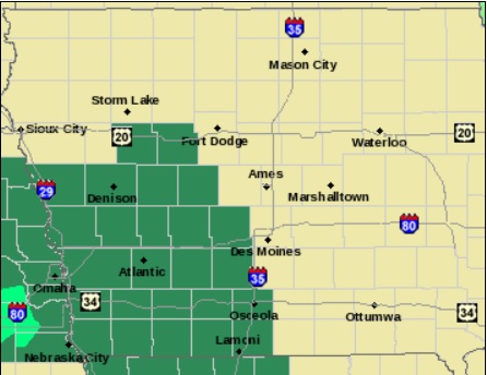
Flash Flood Watch Until Noon; Flood Advisory for parts of Pott. & Mills Counties until 8-a.m.; Flash Flood Warning for parts of Adams, Union, Taylor & Ringgold Counties until 10:30-a.m.**
Today: Showers and thunderstorms, mainly before 1pm. Some of the storms could produce heavy rain. High 78. S @ 5-10. New rainfall amounts between 1 and 2 inches possible.
Tonight: Showers and thunderstorms likely, mainly before 8pm. Mostly cloudy. Low 68. S @ 5-10. New rainfall amounts between a quarter and half of an inch possible.

Friday: A 50 percent chance of showers and thunderstorms. Mostly cloudy. High 79. S-SW @ 5-10. New rainfall amounts between a quarter and half of an inch possible.
Fri. Night: A 30 percent chance of showers and thunderstorms, mainly before 1am. Mostly cloudy, with a low around 62. Light and variable wind. New rainfall amounts between a tenth and quarter of an inch, except higher amounts possible in thunderstorms.

Saturday: Mostly sunny, with a high near 82. Light and variable wind becoming west northwest around 5 mph.

Sunday: A 30 percent chance of showers and thunderstorms. Mostly sunny, with a high near 84.

Rainfall report (8/28/14)

Weather

August 28th, 2014 by Ric Hanson

Rainfall update for Atlantic:  .6″ of rain since 7-a.m. today, bringing the storm system total to 2.81″ as of 12-p.m.

In Atlantic, at the KJAN studios [Official Nat’l. Weather Service reporting site], we received 2.21″ of rain from 7-a.m. Wed. thru 7-a.m. today (8/28). 2 miles NW of Atlantic, 2.16″.

Other reports from NWS observers & area media include (24-hour total as of 7-a.m. unless otherwise indicated):

1.5 miles south of Avoca, .9″; Audubon, .75″; 1 mile north of Beaconsfield (Taylor Co.), 1.4″;  south of Bedford (Taylor Co.), 2.52″ (as of 6-am); 1 mile west of Blockton (Taylor Co.), 1.74“; Clarinda, 2.7″; 5 miles east/south of Denison, 1.42″‘ Emerson, 2.2″; Irwin, 1.08″; 3 miles east of Manning (Carroll Co.), 1.18″; Massena, .63″; 1 mile south of Mt. Ayr, 1.23″; Red Oak, 1″; Treynor, 3.1″; Villisca, 1.42″.

WENDELL L. LENSCH, 86, of Exira (Svcs. 8/30/14)

Obituaries

August 28th, 2014 by Ric Hanson

WENDELL L. LENSCH, 86, of Exira, died Sun., Aug, 24th, at the Exira Care Center. A Celebration of Life Memorial service for WENDELL LENSCH will be held 1:30-p.m. Sat., Aug. 30th, at the Kessler Funeral Home in Exira.

Friends may call at the funeral home, where the family visitation is from 1-p.m. until the time of service, Saturday.

Burial will be in the Exira Cemetery.

WENDELL LENSCH is survived by:

His daughters – Kimberly (Jay) Curtice, of Grand Junction, CO. & Marilee (Dennis) Smith, of Aurora, CO.

His step-children: Tim (Rose) Hartsook, of LaPorte City; Deanne (Guy) Blagg, of Granger; Marsha (Steve) Milder, of Maynard, & Scott Hartsook & Dennis Groenenboom, of Des Moines.

2 grandchildren, 5 step-grandchildren, his in-laws, other relatives & friends.

High-speed Injury accident in Council Bluffs, Wed. evening

News

August 28th, 2014 by Ric Hanson

One person was injured during a collision Wednesday evening, in Council Bluffs. According to Bluffs Police, 21-year old Nathan Maxwell Hall, of Council Bluffs, was transported to Creighton Medical Center in Omaha for treatment of possible, unknown injuries, after his 2007 Pontiac Vibe was hit at a high rate of speed by a 2001 Volvo driven by 21-year old Matthew Howell, of Council Bluffs.

Officials say Howell’s car had been involved in a hit-and-run accident near 29th and Broadway before fleeing north on 29th at speeds of about 60-to 70-miles per hour. A witness said the car “blew through the stop sign” at the intersection of 29th and Avenue B at around 6:10-p.m. at speeds estimated at 70-to 80-mph, and collided with Hall’s Pontiac.

After the initial impact, the Volvo went airborne and hit a power pole. The car then spun around while airborne, and landed on a legally parked, unoccupied 1994 Saturn. A small fire that started in the engine compartment of the Volvo was quickly extinguished by local residents.

Howell and a passenger in his car were trapped in the vehicle, but were extricated and transported to Creighton Hospital, along with Nathan Hall. Damage from the crash amounted to $16,000.

Flood Advisory for SE Pott./Northern Mills Counties

Weather

August 28th, 2014 by Ric Hanson

POTTAWATTAMIE IA-MILLS IA-SARPY NE- 456 AM CDT THU AUG 28 2014

THE NATIONAL WEATHER SERVICE IN OMAHA HAS ISSUED A URBAN AND SMALL STREAM FLOOD ADVISORY FOR… SOUTHEASTERN POTTAWATTAMIE COUNTY and… NORTHERN MILLS COUNTY IN SOUTHWEST IOWA, as well as NORTHEASTERN SARPY COUNTY IN EAST CENTRAL NEBRASKA… UNTIL 800 AM CDT

AT 452 AM CDT…DOPPLER RADAR AND AUTOMATED RAIN GAUGES INDICATED HEAVY RAIN DUE TO THUNDERSTORMS SPREADING INTO WEST CENTRAL IOWA. ONE TO TWO INCHES OF RAIN HAS FALLEN FROM AROUND BELLEVUE TO GLENWOOD…AND AN ADDITIONAL INCH OR SO COULD FALL EARLY THIS MORNING. MANY AREAS WILL SEE BETWEEN 2 AND 3 INCHES OF RAIN FROM BELLEVUE AND GLENWOOD INTO POTTAWATTAMIE COUNTY NEAR OAKLAND. FLOODING OF SMALL STREAMS AND LOW WATER CROSSINGS IS LIKELY.

SOME LOCATIONS THAT WILL EXPERIENCE FLOODING INCLUDE… SOUTHEASTERN COUNCIL BLUFFS…BELLEVUE…GLENWOOD…OAKLAND… TREYNOR…CARSON…PACIFIC JUNCTION…MACEDONIA…OFFUTT AFB… SILVER CITY…HENDERSON…MCCLELLAND…LAKE MANAWA STATE PARK… CAMP MAHA…OLD TOWN PARK AND FARM CREEK PUBLIC WILDLIFE AREA.

PRECAUTIONARY/PREPAREDNESS ACTIONS… EXCESSIVE RUNOFF FROM HEAVY RAINFALL WILL CAUSE FLOODING OF SMALL CREEKS AND STREAMS…AS WELL AS FARM AND COUNTRY ROADS. DO NOT ATTEMPT TO TRAVEL ACROSS FLOODED ROADS. FIND ALTERNATE ROUTES.

Flash Flood Warning: Adams/Union/Taylor/Ringgold Counties

Weather

August 28th, 2014 by Ric Hanson

428 AM CDT THU AUG 28 2014

THE NATIONAL WEATHER SERVICE IN DES MOINES HAS ISSUED A FLASH FLOOD WARNING FOR…RINGGOLD COUNTY -TAYLOR COUNTY – SOUTHERN UNION COUNTY and SOUTHEASTERN ADAMS COUNTY…UNTIL 1030 AM CDT THURSDAY

AT 427 AM CDT…DOPPLER RADAR INDICATED A THUNDERSTORM PRODUCING HEAVY RAIN ACROSS THE WARNED AREA. UP TO TWO INCHES OF RAIN HAVE ALREADY FALLEN WITH LOCALLY HIGHER AMOUNTS POSSIBLE. FLASH FLOODING IS EXPECTED TO BEGIN SHORTLY.

* SOME LOCATIONS THAT WILL EXPERIENCE FLOODING INCLUDE… MOUNT AYR…BEDFORD…LENOX…SUN VALLEY LAKE…CLEARFIELD… DIAGONAL…KELLERTON…BLOCKTON…GRAVITY…TINGLEY…ARISPE…SHARPSBURG…REDDING…SHANNON CITY…KENT…ELLSTON…BENTON…CONWAY…MALOY AND DELPHOS.

PRECAUTIONARY/PREPAREDNESS ACTIONS…

BE ESPECIALLY CAUTIOUS AT NIGHT WHEN IT IS HARDER TO RECOGNIZE THE DANGERS OF FLOODING.

Violence prevention program in Iowa schools teaches bystander intervention

News

August 28th, 2014 by Ric Hanson

The Mentor in Violence Prevention program is teaching Iowa high school and college students how to prevent sexual assault. M-V-P coaches the students to intercede when they recognize signs of looming sexual violence. Iowa State University student Tucker Carrell participated in M-V-P while in high school and says sometimes it’s hard to speak up, but it’s important to act.

“I know one of the biggest things that we consistently talked about and that I really took from this whole program was just listening to things happen, being that bystander,” Carrell says. “It really almost hurts you more and affects you more because you hang on to that and you remember that as well as letting you know whoever is committing some kind of action or harmful act know that’s okay or think that is okay.”

A recent study found one in five women are sexually assaulted while in college. Alan Heisterkamp, director of the Mentors in Violence Prevention Leadership Institute, says silence in the face of disrespect or assault condones sexual violence, so the program teaches bystander intervention.

Heisterkamp says, “You may think that it’s wrong but if we speak out or respond in a way to correct the behavior, often times the abuse or the inappropriate comments can come back on me because the culture of that system doesn’t support those prosocial behaviors.” Carrell and Heisterkamp made their comments on the Iowa Public Radio program, “River to River.”

(Radio Iowa)

King predicts ‘politically nuclear’ reaction if Obama acts along on immigration

News

August 28th, 2014 by Ric Hanson

Republican Congressman Steve King says the reaction will be “politically nuclear” if President Obama bypasses congress and issues an executive order granting some sort of legal status to illegal immigrants. “First, the president has no constitutional authority to make up laws as he wishes they would be, but he threatens to do so anyway,” King says. “…If the president does this and five to nine or more million people get a ‘you are now legal’ slip from the president of the United States, that throws us into an instantaneous constitutional crisis.”

Congress faces another deadline in September to approve a federal budget or pass a stop-gap measure to avoid a government shutdown. King says those discussions may break down if President Obama uses an executive order on immigration policy. “This would be the most blatantly unconstitutional act by any president of the United States ever if he does what his trial balloons and his own threats have promised to do,” King says. “And so, as the intensity of that gets closer and closer, it’s more and more likely that something like that will happen.”

Reports indicate President Obama is considering executive action that would make more undocumented immigrants eligible for green cards and place more people on the “deferred action” list, so deportation proceedings are delayed. White House spokesman Josh Earnest says it “would be a shame” if Republicans in congress decide to shut down the government over the immigration issue.

(Radio Iowa)

KC Chiefs football News (8/28/14)

Sports

August 28th, 2014 by Ric Hanson

GRAND CHUTE, Wis. (AP) — Authorities say a tour bus bringing the Kansas City Chiefs to their Wisconsin hotel before Thursday night’s preseason game against the Green Bay Packers was involved in an accident. The Outagamie (awt-ah-GAY’-mee) County sheriff’s office says it was escorting the Chiefs’ buses from the airport to the hotel Wednesday afternoon when a vehicle entered the intersection and collided with one of the five buses. Two adults and three children were in the vehicle that struck the bus. One of the children had a minor cut to the head and was taken by ambulance to a hospital. No one on the Chiefs’ bus was hurt. Police are investigating.

*****

KANSAS CITY, Mo. (AP) — The change made by the Kansas City Chiefs a few years ago was subtle — one word, really — yet it ushered a pronounced change in the way the franchise viewed its most important fans. Season-ticket holders became known as “season-ticket members.” Suddenly, the entire paradigm shifted. No longer were Chiefs fans merely customers, buying a ticket, attending a game and then heading home afterward. Rather they began to feel as though they were part of the franchise, just as integral to the success or failure of the team as quarterback Alex Smith, coach Andy Reid or even general manager John Dorsey. And by offering those members exclusive gifts and experiences, the Chiefs have rebuilt their season-ticket rolls at a time when many franchises are having a hard time filling stadiums.

*****

CHARLOTTE, N.C. (AP) — Police in North Carolina briefly detained and questioned a man who flew a drone with a camera mounted on it over a stadium during an NFL preseason game. Area news media outlets report that the drone was spotted during the Aug. 17 game between the Carolina Panthers and the Kansas City Chiefs at Bank of America Stadium in Charlotte. The Federal Aviation Administration limits aircraft use near major sporting events, and prohibits unmanned aircraft at sites designated as “Class B” venues, which includes Bank of America Stadium.

Charlotte-Mecklenburg Police department spokesman Rob Tufano did not say what explanation the drone operator gave for using the prohibited aircraft. He said information obtained during questioning was turned over to the FAA, which has jurisdiction in such matters.

Flash Flood Watch for all of southwest/western Iowa (8/28)

News, Weather

August 28th, 2014 by Ric Hanson

A FLASH FLOOD WATCH REMAINS IN EFFECT UNTIL NOON TODAY (8/28) FOR ALL OF THE COUNTIES IN THE KJAN LISTENING AREA. 

Flash Flood Watch for counties shown in green.

Flash Flood Watch for counties shown in green.

WIDESPREAD RAINFALL AMOUNTS OF 1 TO 2 INCHES WITH LOCALLY HIGHER AMOUNTS UP TO 3 INCHES ARE POSSIBLE OVERNIGHT THROUGH MIDDAY THURSDAY. THESE THUNDERSTORMS WILL BE EFFICIENT RAIN PRODUCERS…MEANING THE ENVIRONMENT IS SUITED FOR RAINFALL RATES IN EXCESS OF 1 TO 2 INCHES PER HOUR AT TIMES.

WITH THE ANTICIPATED RAINFALL RATES ON TOP OF AN ALREADY VERY SATURATED GROUND…A FLASH FLOOD COULD OCCUR IN A VERY SHORT TIME FRAME AND IS ESPECIALLY DANGEROUS AT NIGHT.

PRECAUTIONARY/PREPAREDNESS ACTIONS…

A FLASH FLOOD WATCH MEANS THAT CONDITIONS MAY DEVELOP THAT LEAD TO FLASH FLOODING. FLASH FLOODING IS A VERY DANGEROUS SITUATION. YOU SHOULD MONITOR LATER FORECASTS AND BE PREPARED TO TAKE ACTION SHOULD FLASH FLOOD WARNINGS BE ISSUED.