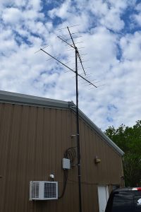
(Radio Iowa) – A couple of donations will allow the Iowa Department of Natural Resources to build out a wildlife tracking system across the state. D-N-R Avian Ecologist, Anna Buckardt Thomas, says the system called Motus is a series of antennae stations and tracking tags that emit a radio signal. “And if they go by a station that’s listening on that same frequency, that station can detect those wildlife. And so we can build a really large scale understanding of movements of these wildlife,” she says.
There are currently 18 stations in Iowa and the 120-thousand dollars in donations will allow them to expand that by 20 stations to create a corridor from east to west across the center of the state. “And then stations bordering the Mississippi and Missouri Rivers. And so that way, we’ll be able to understand bird movement along those major river corridors and that movement as well,” Thomas says. “And then, because we’ll have that fence through the middle of the state, we’re likely to detect pretty much any tagged wildlife that would come to Iowa.”
The tags are put on smaller migratory birds and insects like butterflies and dragonflies. The tags vary in size based on what’s being tagged, and that also dictates how long its battery will last. “For something like an insect, that tag lasts maybe a handful of weeks or a month. And for something like a small bird, it might last six months in a large bird, you might get a tag that can last over a year,” she says.

Motus tower station at the Iowa DNR’s Black Hawk Unit office, near Early. Photo courtesy of the Iowa DNR.
Thomas says different groups tag different species based on what they want to research, and she says there is always some sort of tagging going on. She says the stations all over the western hemisphere and Iowa provide a variety of information that the D-N-R can review. “So if we can learn about particular pathways or particular habitats that are really important for these migratory species, we can help inform our conservation and management of those areas,” Thomas says. The information is also available to the public at the website motus.org.
“And you can explore a map of all the existing stations, you can click on a station and learn about what animals have flown by or moved by and then detected by that station,” she says. “You can look up what species of wildlife are being tagged on the system. You can look up a specific tagging project if you’re aware of it, though. There’s a lot of really cool data to explore.” Thomas says you can also build maps of individual birds or collections of birds to see where they’re being detected as they move during migration periods.
The D-N-R hopes to add the additional sites in the next five years.


