United Group Insurance

Skyscan Forecast 01-31-2015

Podcasts, Weather

January 31st, 2015 by admin

Skyscan Forecast Saturday 01/31/2015

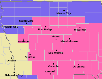
Winter Storm Warning for Montgomery, Page, Monona, Harrison, Shelby, Pottawattamie Counties from 6pm this evening to 9pm Sunday.

Winter Storm Warning for Cass, Sac, Crawford, Carroll, Greene, Audubon, Guthrie, Adair, Madison, Adams, Union, Taylor, and Ringgold Counties from 7pm this evening to 9pm Sunday.

Winter Weather Advisory for Mills and Fremont Counties from 9pm this evening to 6pm Sunday.

Today: Rain and snow, becoming all snow after 5pm. High near 38. Southwest wind 10 to 15 mph becoming south southeast in the afternoon. Total daytime snow accumulation of less than a half inch possible.

Tonight: Snow. Low around 22. South southeast wind 10 to 15 mph becoming north northeast after midnight. New snow accumulation of 3 to 7 inches possible.

Sunday: Snow with patchy blowing snow before 3pm, then snow likely with patchy blowing snow after 3pm. Temperature falling to around 12 by 4pm. Wind chill values as low as -5. Windy, with a north wind 15 to 25 mph, with gusts as high as 35 mph. New snow accumulation of 2 to 4 inches possible.

Sunday Night: Cloudy, then gradually becoming partly cloudy, with a low around -2. Wind chill values as low as -10. Windy, with a north wind 15 to 20 mph decreasing to 5 to 10 mph after midnight. Winds could gust as high as 30 mph.

Monday: A slight chance of snow after noon. Partly sunny, with a high near 21. Light and variable wind becoming south 10 to 15 mph in the morning. Winds could gust as high as 20 mph.

Monday Night: A slight chance of snow before midnight. Mostly cloudy, with a low around 15.

Tuesday: Partly sunny, with a high near 36. Breezy.

Wednesday: Mostly cloudy, with a high near 24. Blustery.

Play

Winter Weather Advisory for Mills and Fremont Counties

Weather

January 31st, 2015 by admin

NATIONAL WEATHER SERVICE OMAHA/VALLEY NE
511 AM CST SAT JAN 31 2015

...POTENT STORM SYSTEM TO AFFECT THE REGION THROUGH SUNDAY...

.A MIX OF SNOW AND RAIN AND SNOW WILL DEVELOP AND SPREAD ACROSS
THE REGION TODAY...CHANGING TO ALL SNOW LATER TODAY AND
TONIGHT...WITH VERY STRONG WINDS AND BLOWING SNOW SUNDAY.

MILLS-FREMONT-
...WINTER WEATHER ADVISORY IN EFFECT FROM 9 PM THIS EVENING TO
6 PM CST SUNDAY...

THE NATIONAL WEATHER SERVICE IN OMAHA/VALLEY HAS ISSUED A WINTER
WEATHER ADVISORY FOR SNOW AND BLOWING SNOW...WHICH IS IN EFFECT
FROM 9 PM THIS EVENING TO 6 PM CST SUNDAY.

* TIMING...A MIX OF RAIN AND SNOW WILL CHANGE TO ALL SNOW THIS
  THIS AFTERNOON AND CONTINUE TONIGHT. SOME ADDITIONAL LIGHT SNOW
  ACCUMULATIONS WILL BE POSSIBLE SUNDAY. INITIALLY TEMPERATURES
  WILL BE NEAR OR ABOVE FREEZING WITH FALLING TEMPERATURES TONIGHT
  AND SUNDAY.

* UNCERTAINTY...PRECIPITATION IS LIKELY...HOWEVER MELTING DURING
  THE DAY AND HOW QUICKLY THE PRECIPITATION CHANGES OVER TO ALL
  SNOW WILL AFFECT EVENTUAL TOTAL SNOW AMOUNTS.

* STORM TOTAL SNOW...ACCUMULATIONS OF 2 TO 6 INCHES.

* WINDS/VISIBILITY...NORTHEAST WINDS TONIGHT WILL BECOME NORTHWEST
  20 TO 30 MPH AND GUSTY LATE TONIGHT AND SUNDAY.

* MAIN IMPACT...ROADS WILL BECOME SNOW COVERED AND HAZARDOUS.
  BLOWING SNOW ON SUNDAY WILL REDUCE VISIBILITY AND MAKE IT
  DIFFICULT TO KEEP THE ROADS CLEAR...ESPECIALLY IN OPEN AND
  RURAL AREAS.

* OTHER IMPACTS...THE COLD COMBINED WITH THE WIND SUNDAY WILL
  LOWER WIND CHILLS TO A RANGE OF 10 ABOVE TO 10 BELOW ZERO
  SUNDAY.

PRECAUTIONARY/PREPAREDNESS ACTIONS...

A WINTER WEATHER ADVISORY FOR SNOW MEANS THAT PERIODS OF SNOW
WILL CAUSE PRIMARILY TRAVEL DIFFICULTIES. BE PREPARED FOR SNOW
COVERED ROADS AND LIMITED VISIBILITIES...AND USE CAUTION WHILE
DRIVING.

A WINTER WEATHER ADVISORY FOR BLOWING SNOW MEANS THAT
VISIBILITIES WILL BE LIMITED DUE TO STRONG WINDS BLOWING SNOW
AROUND. USE CAUTION WHEN TRAVELING...ESPECIALLY IN OPEN AREAS.

Iowa Weather Summary & forecast expectation: Sat., 1/31/15

Weather

January 31st, 2015 by Ric Hanson

(issued 4:12-a.m. Sat,/NWS Des Moines)

CLOUDS INCREASED FROM THE SOUTH ACROSS IOWA OVERNIGHT ALTHOUGH THERE WAS NO PRECIPITATION AS OF YET. LOWS REACHED THE UPPER TEENS TO LOWER 30S…BUT THE CLOUDS AND SOUTHWEST WINDS OF 5 TO 10 MPH LED TO TEMPERATURES SLOWLY RISING ABOVE THOSE VALUES HEADING TOWARD DAYBREAK.

Counties in pink have a Winter Storm Warning in effect from 7-pm 1/31-thru 9-p.m. 2/1/15

Counties in pink have a Winter Storm Warning in effect from 7-pm 1/31-thru 9-p.m. 2/1/15

THE WEATHER WILL BECOME MUCH MORE ACTIVE THROUGH THE WEEKEND HOWEVER AS A LARGE LOW PRESSURE SYSTEM TRACKS FROM THE SOUTHWEST UNITED STATES INTO THE MID MISSISSIPPI VALLEY BY SUNDAY. A MIX OF RAIN AND SNOW WAS ALREADY FALLING ACROSS KANSAS THIS MORNING AND SIMILAR PRECIPITATION WILL EXPAND INTO IOWA AND SURROUNDING STATES LATER TODAY.

BY TONIGHT THE PRECIPITATION WILL SWITCH TO NEARLY ALL SNOW AND CONTINUE THROUGH SUNDAY. WIDESPREAD MODERATE TO HEAVY SNOW AMOUNTS ARE EXPECTED FROM IOWA INTO ILLINOIS WHERE 6 TO 10 INCHES MAY FALL AND WINTER STORM WARNINGS ARE IN EFFECT. WINDS WILL INCREASE AS THE SYSTEM EXITS SUNDAY AS WELL COMPOUNDING THE STORM EFFECTS WITH BLOWING AND DRIFTING SNOW.

THE PRECIPITATION WILL END BY SUNDAY NIGHT BUT BITTERLY COLD TEMPERATURES WILL RETURN HEADING INTO THE WORK WEEK. LOWS BY MONDAY MORNING ARE FORECAST TO BE IN THE SINGLE DIGITS ABOVE AND BELOW ZERO WITH WIND CHILLS IN THE SINGLE DIGITS AND TEENS BELOW ZERO.

Ernst to lead subcommittee with USDA oversight

News

January 31st, 2015 by Ric Hanson

Senator Joni Ernst is now chair of a subcommittee that oversees U-S-D-A programs that promote renewable energy and broadband expansion. “Agriculture is the life-blood of Iowa and so this subcommittee will focus on improving quality of life for Iowa farmers and farmers across the country,” Ernst says. Ernst is a member of the Senate Ag Committee and just this week she was named chairman of the subcommitee on rural development and energy. Ernst says identifying ways to “enhance” rural life is a priority for the subcommittee and she sees former Iowa Governor Tom Vilsack — who is U.S. Secretary of Agriculture — as a partner.

“I know that despite differences between our two parties, he always did work very hard for the people of Iowa, so I do look forward to having those discussions with him,” Ernst says. Ernst is also a member of the Senate Armed Services Committee. Anti-war protesters disrupted an Armed Services Committee hearing this week and Ernst says it was an unfortunate distraction from the testimony of former Secretaries of State Henry Kissinger, George Schultz and Madeleine Albright.

“I appreciate the fact that people have the right to protest, but we do have a sense of decorum and we do wish to hear from the guests who visit with us in the senate committees,” Ernst says. Arizona Senator John McCain is chairman of the committee and he called the protesters “low-life scum.” Ernst says those are McCain’s words, not hers, and it’s up to McCain to defend that kind of “verbiage.” Ernst also suggests the protesters might be better off if they presenting their views “in a more civil manner.” The “Code Pink” protesters confronted former Secretary of State Henry Kissinger as the 91-year-old entered the room and waved handcuffs near his head as he sat down at the witness table.

(Radio Iowa)

Bluffs man set to stand trial over sex abuse case

News

January 31st, 2015 by Ric Hanson

A Council Bluffs man accused of having an inappropriate relationship with a teenager, will stand trial Feb. 5th. The Daily NonPareil reports 48-year old youth softball coach John Osborn is charged with four counts of third-degree sexual abuse upon a minor, with regard to an incident involving a 14-year-old friend of his daughter. The incident allegedly occurred in July, 2014.

Osborn has pleaded not guilty to the charges. According to the Council Bluffs Police Department, the teen was a member of the team Osborn coached. The victim stated she and Osborn began exchanging text messages in June 2014.

Clarinda teens arrested Friday in connection with a burglary Thursday

News

January 31st, 2015 by Ric Hanson

Police in Clarinda report two area teens were arrested Friday in connection with a residential burglary that took place Thursday afternoon. Police Chief Keith Brothers says at around 3:40-p.m., Thursday, officers responded to a report of a burglary in progress at 100 E. Nishna Street. When they arrived, the suspected burglars had already fled the scene. Tyler Price, who owns the home, was not home at the time of the burglary.

When Price returned home, he discovered property valued at approximately $700 had been stolen. On Friday, January 30th police arrested two juvenile males, ages 15 and 16, for felony burglary and theft of property from Price’s home. Both juveniles were transported to the Southwest Iowa Juvenile Detention Center in Council Bluffs.

The arrests will be referred to Page County Juvenile Court Services and to the juvenile division of the Page County Attorney’s Office for additional action.

No. 12 Wichita St, No. 18 Northern Iowa set for MVC showdown

Sports

January 31st, 2015 by Ric Hanson

DES MOINES, Iowa (AP) — Wichita State’s unbeaten romp through the Missouri Valley Conference has brought both notoriety and scrutiny to the league. Northern Iowa is getting its chance to show that the Valley is about more than just the Shockers.

The 18th-ranked Panthers (19-2, 8-1 MVC) host Number 12 Wichita State (19-2, 9-0) on Saturday in one of the most high-profile games in league history. It’s the first Valley game between ranked opponents since 1982 — and biggest threat yet to Wichita’s 27-game winning streak in the league.

Iowa early News Headlines: Sat., 1/31/2015

News

January 31st, 2015 by Ric Hanson

Here is the latest Iowa news from The Associated Press

DES MOINES, Iowa (AP) — Two storm systems merging over the Midwest this weekend are expected to produce significant snowfall across Iowa and lighter accumulation in Nebraska. Meteorologist Melinda Beerends says a storm entering the region from the southwest and another dropping out of Canada will meet. She says snowfall will get heavier as the storm moves through the state, with central and southeastern Iowa anticipating higher totals.

WASHINGTON (AP) — Former Republican presidential nominee Mitt Romney will not run for president in 2016. Three weeks after unexpectedly saying he was considering a third campaign for the White House, the former Massachusetts governor told members of his staff during a Friday conference call that he is out of race.

MARSHALLTOWN, Iowa (AP) — An April trial has been scheduled for a 31-year-old man accused of shooting a woman earlier this month at a motel in Marshalltown. Online court records say Jean Martinez-Velazquez of Marshalltown has pleaded not guilty to attempted murder and several other charges. The Marshalltown Times-Republican says his trial is set to begin April 7th.

IOWA CITY, Iowa (AP) — A judge says he won’t second-guess the University of Iowa’s decision to reassign an employee who is suing for political discrimination. U.S. District Judge James Gritzner denied Teresa Wagner’s request to be returned to the law school’s writing center. Gritzner cancelled a hearing that had been set for next week.

NWS weather forecast for Cass & area Counties, Sat., 1/31/15

Weather

January 31st, 2015 by Ric Hanson

Today: Rain and snow before 3pm, then rain between 3pm and 4pm, then rain and snow after 4pm. High near 38. Southwest wind 7 to 11 mph becoming south southeast in the afternoon. Chance of precipitation is 90%. Total daytime snow accumulation of less than a half inch possible.

**WINTER STORM WARNING FROM 7-PM SAT. THRU 9-PM SUNDAY**
Tonight: Snow. Low around 21. Southeast wind 6 to 14 mph becoming north northeast after midnight. Winds could gust as high as 18 mph. Chance of precipitation is 100%. New snow accumulation of 3 to 7 inches possible.
Sunday: Snow with patchy blowing snow before 3pm, then snow likely with patchy blowing snow after 3pm. Temperature falling to around 10 by 5pm. Wind chill values as low as -10. Windy, with a north wind 16 to 24 mph, with gusts as high as 33 mph. Chance of precipitation is 100%. New snow accumulation of 1 to 3 inches possible.
Sunday Night: Cloudy, then gradually becoming partly cloudy, with a low around -3. Wind chill values as low as -10. Blustery, with a north northwest wind 15 to 20 mph decreasing to 5 to 10 mph after midnight. Winds could gust as high as 28 mph.
Monday: A 20 percent chance of snow after noon. Partly sunny, with a high near 22. Light and variable wind becoming south 10 to 15 mph in the morning. Winds could gust as high as 21 mph.
Monday Night: A 20 percent chance of snow before midnight. Mostly cloudy, with a low around 15.
Tuesday: Partly sunny, with a high near 36. Breezy.

Winter Storm Warning issued for Cass & areas Counties

News, Weather

January 31st, 2015 by Ric Hanson

331 AM CST SAT JAN 31 2015: AREA COUNTIES…SAC-CRAWFORD-CARROLL-AUDUBON-GUTHRIE-CASS- DALLAS-ADAIR-MADISON-ADAMS-UNION-TAYLOR-RINGGOLD

WINTER STORM WARNING IN EFFECT FROM 7 PM THIS EVENING TO 9 PM CST SUNDAY

THE NATIONAL WEATHER SERVICE IN DES MOINES HAS ISSUED A WINTER STORM WARNING FOR SNOW AND BLOWING SNOW…WHICH IS IN EFFECT FROM 7 PM THIS EVENING TO 9 PM CST SUNDAY.

* TIMING…RAIN WILL CHANGE TO SNOW BY THIS EVENING AND ACCUMULATE HEAVILY OVERNIGHT. SNOW WILL CONTINUE TO FALL THROUGH THE DAY SUNDAY WITH INCREASING WINDS.

* STORM TOTAL SNOW…ACCUMULATIONS OF 7 TO 10 INCHES WITH LOCALLY HIGHER AMOUNTS.

* WINDS/VISIBILITY…TURNING TO NORTHEAST 10 TO 20 MPH BY EARLY SUNDAY MORNING…THEN BECOMING NORTH 15 TO 25 MPH AND GUSTY BY SUNDAY AFTERNOON.

* IMPACTS…ROADS WILL BECOME SNOW COVERED AND HAZARDOUS. BLOWING SNOW ON SUNDAY WILL REDUCE VISIBILITY AND MAKE IT DIFFICULT TO CLEAR THE ROADS…ESPECIALLY IN OPEN AND RURAL AREAS.

PRECAUTIONARY/PREPAREDNESS ACTIONS…

A WINTER STORM WARNING FOR HEAVY SNOW MEANS SEVERE WINTER WEATHER CONDITIONS ARE EXPECTED OR OCCURRING. SIGNIFICANT AMOUNTS OF SNOW ARE FORECAST THAT WILL MAKE TRAVEL DANGEROUS. ONLY TRAVEL IN AN EMERGENCY. IF YOU MUST TRAVEL…KEEP AN EXTRA FLASHLIGHT…FOOD…AND WATER IN YOUR VEHICLE IN CASE OF AN EMERGENCY. ANY REPORTS OF SNOW…SLEET AND FREEZING RAIN ACCUMULATIONS ARE MUCH APPRECIATED AND CAN BE RELAYED DIRECTLY TO THE NATIONAL WEATHER SERVICE USING TWITTER HANDLE NWS DES MOINES…HASHTAG
NWSDMX OR POST TO THE NWS DES MOINES FACEBOOK PAGE.