

135 AM CDT SUN JUN 7 2015
THE NATIONAL WEATHER SERVICE HAS CANCELLED SEVERE THUNDERSTORM WATCH 266 FOR THE FOLLOWING AREAS
IN IOWA THIS CANCELS 2 COUNTIES IN SOUTHWEST IOWA
HARRISON SHELBY

135 AM CDT SUN JUN 7 2015
THE NATIONAL WEATHER SERVICE HAS CANCELLED SEVERE THUNDERSTORM WATCH 266 FOR THE FOLLOWING AREAS
IN IOWA THIS CANCELS 2 COUNTIES IN SOUTHWEST IOWA
HARRISON SHELBY
HARRISON-SHELBY-
INCLUDING THE CITIES OF…MISSOURI VALLEY…WOODBINE…LOGAN…
DUNLAP…HARLAN ; 134 AM CDT SUN JUN 7 2015
…FLASH FLOOD WATCH IS CANCELLED…
THE FLASH FLOOD WATCH FOR A PORTION OF SOUTHWEST IOWA HAS BEEN CANCELLED. THE STRONGEST STORMS HAVE MOVED OUT OF THE WATCH AREA AND THE THREAT OF WIDESPREAD FLASH FLOOD HAS DECREASED COMPARED TO SATURDAY EVENING.
AUDUBON IA-GUTHRIE IA-
131 AM CDT SUN JUN 7 2015
…THE SEVERE THUNDERSTORM WARNING FOR AUDUBON AND WESTERN GUTHRIE COUNTIES HAS EXPIRED…
THE STORMS WHICH PROMPTED THE WARNING HAVE WEAKENED BELOW SEVERE LIMITS…AND NO LONGER POSE AN IMMEDIATE THREAT TO LIFE OR PROPERTY. THEREFORE THE WARNING HAS BEEN ALLOWED TO EXPIRE. HOWEVER GUSTY
WINDS AND HEAVY RAIN ARE STILL POSSIBLE WITH THESE THUNDERSTORMS.
A SEVERE THUNDERSTORM WATCH REMAINS IN EFFECT UNTIL 600 AM CDT FOR SOUTHWESTERN IOWA.
1259 AM CDT SUN JUN 7 2015
SIGNIFICANT WEATHER ADVISORY FOR POTTAWATTAMIE…SOUTHEASTERN HARRISON AND SOUTHWESTERN SHELBY COUNTIES UNTIL 130 AM CDT…
AT 1259 AM CDT…DOPPLER RADAR WAS TRACKING A LINE OF STRONG THUNDERSTORMS ALONG A LINE EXTENDING FROM NEAR SHELBY TO NEAR TREYNOR…AND MOVING EAST AT 45 MPH. DIME SIZE HAIL AND WINDS IN EXCESS OF 40 MPH WILL BE POSSIBLE WITH THESE STORMS.
LOCATIONS IMPACTED INCLUDE…
OAKLAND…AVOCA…TREYNOR…UNDERWOOD…CARSON…WALNUT…SHELBY… MINDEN…NEOLA…HANCOCK…MCCLELLAND…ARROWHEAD PARK…FARM CREEK PUBLIC WILDLIFE AREA AND BOTNA BEND PARK.
THIS INCLUDES THE FOLLOWING HIGHWAYS…
HIGHWAY 59 IN IOWA BETWEEN MILE MARKERS 44 AND 64.
INTERSTATE 80 IN IOWA BETWEEN MILE MARKERS 14 AND 48.
A SEVERE THUNDERSTORM WATCH REMAINS IN EFFECT UNTIL 600 AM CDT FOR SOUTHWESTERN IOWA.
1248 AM CDT SUN JUN 7 2015
THE NATIONAL WEATHER SERVICE IN DES MOINES HAS ISSUED A
* SEVERE THUNDERSTORM WARNING FOR…AUDUBON COUNTY IN WEST CENTRAL IOWA…WESTERN GUTHRIE COUNTY IN WEST CENTRAL IOWA…
* UNTIL 130 AM CDT
* AT 1247 AM CDT…SEVERE THUNDERSTORMS WERE LOCATED ALONG A LINE EXTENDING FROM 4 MILES WEST OF COON RAPIDS TO 6 MILES SOUTHWEST OF AUDUBON…MOVING EAST AT 50 MPH.
HAZARD…60 MPH WIND GUSTS.
SOURCE…RADAR INDICATED.
IMPACT…EXPECT DAMAGE TO ROOFS…SIDING AND TREES.
* LOCATIONS IMPACTED INCLUDE…
AUDUBON…GUTHRIE CENTER…LAKE PANORAMA…EXIRA…ELK HORN… BAYARD…KIMBALLTON…BAGLEY…GRAY…AUDUBON COUNTY AIRPORT AND SPRINGBROOK STATE PARK.
PRECAUTIONARY/PREPAREDNESS ACTIONS…
FOR YOUR PROTECTION MOVE TO AN INTERIOR ROOM ON THE LOWEST FLOOR OF A BUILDING. TORRENTIAL RAINFALL IS OCCURRING WITH THESE STORMS…AND MAY LEAD TO FLASH FLOODING. DO NOT DRIVE YOUR VEHICLE THROUGH FLOODED ROADWAYS.
COUNCIL BLUFFS, Iowa (AP) – The Missouri River between Council Bluffs, Iowa, and Omaha, Nebraska, is in for a spring cleaning this month. The Council Bluffs Daily Nonpareil reports that three groups – Missouri River Relief of Columbia, Missouri, and Back to the River and Fontenelle Forest, both of Omaha – will team up for the river cleanup project on June 13.
The event headquarters will be the boat ramps at Lake Manawa State Park in Council Bluffs, with the cleanup running from 9 a.m. until noon. Organizers will provide volunteers with gloves, trash bags, an event T-shirt and reusable water bottle. Volunteers are encouraged to bring sunglasses and bug spray and wear appropriate clothes for the work, including boots or tennis shoes and long pants to protect against poison ivy.
ROSE MARY REINIG, 83, of Harlan, died Fri., June 5th, at the Salem Lutheran Home in Elk Horn. A Mass of Christian Burial service for ROSE MARY REINIG will be held 10:30-a.m. Tue., June 9th, at St. Michael’s Catholic Church in Harlan. Pauley-Jones Funeral Home in Harlan has the arrangements.
Visitation at the funeral home is from Noon until 8-pm Mon., June 8th, with the family greeting friends from 6-until 8-pm, and a Wake service at 7-p.m.
Burial will be in the Harlan Cemetery.
ROSE MARY REINIG is survived by:
Her daughters – Joan (Ralph) Bruck, of Harlan; Teresa (Bryan Cisar) Reinig, of Papillion, NE; Rita (Grant) Christensen, of Omaha, & Ann (Scott) Mahlberg, of Houston, TX.
Her sons – Thomas Reinig, of Pueblo, CO; & Jim (Lisa) Reinig, of Tucson, AZ.
Her brothers – Fred (Ann) Schmiedeler, of South Bend, IN, & Pat (Peggy) Schmiedeler, of Rio Rancho, NM.
Her sisters – Dorothy (Donald) Flake, of Florissant, MO., & Martha Schmiedeler, of Rio Rancho, NM.
4 grandchildren, 2 great-grandchildren, and her sister-in-law.
Red Oak Police, Saturday, arrested 32 year old Joseph Aaron Nelson, of Red Oak. Nelson was taken into custody for domestic abuse assault, and was being held without bond in the Montgomery County Law Enforcement Center.
HEAVY RAINFALL COULD CAUSE FLASH FLOODING INTO EARLY SUNDAY MORNING. THUNDERSTORMS WILL DEVELOP ACROSS NORTHEAST NEBRASKA TONIGHT AND ARE EXPECTED TO PERSIST OVER THE REGION INTO THE OVERNIGHT.
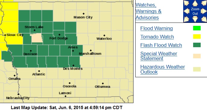
Counties in green are included in a Flash Flood Watch
DUE TO THE INTENSE RAINFALL RATES EXPECTED...A FLASH FLOOD WATCH HAS BEEN ISSUED FOR MONONA-HARRISON-AND SHELBY COUNTIES FROM 7-PM SAT. THROUGH LATE TONIGHT AND EARLY SUNDAY. A FLASH FLOOD WATCH GOES INTO EFFECT AT 8-P.M. FOR SAC-CRAWFORD-CARROLL-AUDUBON-GUTHRIE AND DALLAS COUNTIES IN OUR AREA.
RAINFALL RATES ARE EXPECTED TO BE HIGH AND WILL DROP LOCALLY HEAVY AMOUNTS OF RAIN.
PRECAUTIONARY/PREPAREDNESS ACTIONS…
A FLASH FLOOD WATCH MEANS THAT CONDITIONS MAY DEVELOP THAT LEAD TO FLASH FLOODING. FLASH FLOODING IS A VERY DANGEROUS SITUATION. YOU SHOULD MONITOR LATER FORECASTS AND BE PREPARED TO TAKE ACTION SHOULD FLASH FLOOD WARNINGS BE ISSUED.


