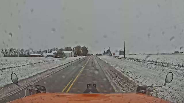
It’s no Halloween prank, snow is falling in NW Iowa this morning
October 31st, 2024 by Ric Hanson
(Radio Iowa) – It’s neither a trick nor a treat as a surprise snowfall is blanketing parts of northwest Iowa this Halloween morning. A photo taken by an Iowa D-O-T snowplow camera in the seven o’clock hour shows flurries flying and snow on the ground. National Weather Service meteorologist Rod Donavon says they’re the state’s first flakes of the season, and October 31st is a little early for the first snowfall, but it’s not unprecedented. “We do have some light snow moving across northwest Iowa up into south central Minnesota, with that strong system that moved through. We have had some minor accumulations across northwest Iowa,” Donavon says. “We have seen some plow cameras, at least, showing a little bit of accumulation on roadways up in that area. Fortunately, as we go through the day today and get a little bit of sunlight, most of that will melt off the roadways.”
Forecasters issued a host of advance warnings about Wednesday’s storm, how it might include hail, high winds, heavy rain and tornadoes, but there was no mention of possible snow. Was this unexpected? “Yeah, definitely, it’s a little bit of a surprise that it’s gotten down into northwest Iowa,” Donavon says. “The main forecast was certainly up north, up into Minnesota, where the cold air was, and it looks like some of that cold air has filtered down into the state.”

IA DOT Snowplow cam 10-31-24, U-S Hwy 59 in NW Iowa
Some light snow may continue falling into north-central Iowa this morning, but little-to-no accumulation is expected. Wednesday’s powerful thunderstorms dropped temperatures some 30 degrees and also dropped plenty of rain. “The heaviest amounts were across east central Iowa, kind of along that Interstate 80 corridor from about Grinnell and then eastward towards the Quad Cities,” Donavon says. “We did have a couple reports right around Montezuma, in that area, right around two and quarter, two and a half inches, which is the highest in the state.”
Both Des Moines and Waterloo set rainfall records for the date, with each reporting over an inch-and-a-half, breaking records set in 1974. At least five Iowa counties had tornado warnings late Wednesday afternoon and evening, though Donavon says it doesn’t appear there were any twisters that reached the ground. “We have not had anything confirmed at this point, as far as tornado touchdowns,” he says. “So far, what we’ve had is strong wind gusts with some damaging winds over 60 miles per hour.”
The most significant damage reported is on a Clarke County farmstead, with a barn destroyed and a grain bin damaged. Peak winds of 62 miles an hour were clocked in Appanoose and Lucas counties, while there were multiple hail reports, including golf ball-sized hail near Clear Lake. The new map out this morning from the U-S Drought Monitor shows almost 88-percent of the state in moderate to severe drought, but it’s based on data from before Wednesday’s storms.


