


Drought conditions worsen in Iowa, but rain is in the forecast
October 24th, 2024 by Ric Hanson
(Radio Iowa) – A map released this (Thursday) morning by the U-S Drought Monitor shows -all- of Iowa is again experiencing some level of drought. Last week’s map showed about two-and-a-half percent of the state was still in the normal category, but even that’s gone now. The new map indicates about 16-percent of Iowa is abnormally dry, all in south-central Iowa, while almost two-thirds of the state is in moderate drought. That leaves about 19-percent that’s in severe drought, with large patches of that category in northwest, west-central and northeast Iowa. As yet, none of the state’s in the worst two levels of extreme or exceptional drought. 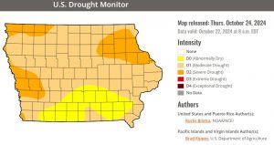
—-
A steady, soaking rain would be welcome, and not hail or high winds, but parts of Iowa may see all of them later today (Thursday). National Weather Service meteorologist Rod Donavon says the majority of Iowa is quite parched, so the expected downpour will be a refreshing change of pace. “We do have actually a pretty strong system coming into the state by later this afternoon, into this evening,” Donavon says. “We are expecting showers and thunderstorms to develop. It looks like in most areas, that development occurs sometime between 6 PM and midnight, and we may have a few strong storms, and we could have some large hail with those as well.”
While some areas are 50-50 for rainfall, parts of eastern Iowa are closer to a 100-percent chance for rain, though he says the quantities that are expected vary. “As you get up into the Webster City and Fort Dodge area, actually parts to the northwest might actually be our lower areas with the precipitation. They’re generally at around a 10th of an inch or so is the main forecast for there,” Donavon says. “Farther to the southeast, as you get south of Highway 30, basically Ames and Marshalltown, and east of I-35, there actually could be some areas that receive over an inch of rain.”
Dry conditions are expected to return for the weekend with highs in the 60s. The latest 6 to 10-day outlook shows a chance for more precipitation late next week.

