


Powerful thunderstorms bring winds of 100+ MPH in NE Iowa
July 16th, 2024 by Ric Hanson
(Radio Iowa) – Severe storms moved across Iowa late Monday afternoon and early evening, bringing large hail, high winds and at least one tornado.
The first warning in western Iowa was for the Crawford and Carroll County areas, at around 3:40-p.m. According to the National Weather Services, tennis ball-size hail was reported by the public, in Vail. Hail the size of eggs fell in Westside, quarter-size hail was reported in Arcadia, and winds gusting to near 65-miles per hour were reported near Manning. Winds gusting to near 55-mph were noted northwest of Adel.
The New Vienna/Luxemburg Fire Department reported a wind gust of 102 miles an hour, with several reports of damage to structures, trees and vehicles. Delaware County Emergency Management Coordinator Mandy Bieber says the winds were exceptional. “Significant wind speeds in the 80 mile an hour range,” Bieber says, “and it seems like it did significantly increase as it moved across the county in Dubuque County, maybe took a little harder hit than what we did.”
Bieber says there are no reports of anyone hurt, but there are multiple reports of damage. “The Earlville area, we’re seeing some pictures of trees that have been completely blown over, that are larger, and a lot of vinyl fencing and lighter items receiving some damage as well,” Bieber says. “We did have one report of a topper ripped off of a truck.”
Tornado warnings were issued in portions of Buchanan, Delaware, Linn, Polk, Jones and Dubuque counties, as several funnel clouds were spotted. Flash flooding was reported, with Highway 61 covered with water near Zwingle and flooded roads west of New Vienna. “Lines down in several different areas, the fire departments and public works guys are all out taking care of that,” Bieber says. “Obviously, with the lines being down, we are seeing some power outages.”
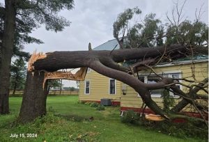
Near Backbone State Park (Photo by Dan Murhpy, Delaware County. via
MidAmerican Energy reported 40-thousand customers without power at 11 P-M, mostly in the Des Moines, Iowa City and Davenport areas. Meteorologist Dylan Dodson, at the National Weather Service in Johnston, says one twister was spotted. Dodson says, “We had some severe storms that caused some extensive tree damage and some downed power lines through the Des Moines metro, with one tornado confirmed in Polk County.” That tornado was reported near Windsor Heights and Grimes. The Montgomery County Emergency Management Agency reported a funnel cloud was observed a little after 6-p.m., Monday, about six-miles southwest of Grant.
On the plus side, Dodson says the storm broke the extreme heat wave, and high temperatures through the rest of the week should be in the 70’s and 80’s.
(Reporting by Janelle Tucker, KMCH, Manchester and Pat Powers, KQWC, Webster City)
