


NWS confirms 3 tornadoes occurred in Montgomery County May 21st
May 23rd, 2024 by Ric Hanson
Red Oak Tornado
Rating: EF1
Estimated Peak Wind: 107 mph
Path Length /statute/: 2.95 miles
Path Width /maximum/: 70 yards
Start Date: 05/21/2024
Start Time: 02:35 PM CDT
End Date: 05/21/2024
End Time: 02:40 PM CDT
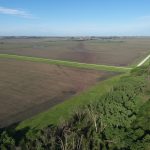
Red Oak Tornado path looking southwest from E Nishnabotna River
Survey Summary:
A tornado developed near Evergreen Avenue and tracked over open fields toward the northeast. Emergency management drone imagery shows the exact track of the tornado through the field, including where it turned toward the east for a bit. The tornado crossed the Nishnabotna River while turning slightly to the northeast again, causing substantial tree damage near the river. It then badly damaged a building at the city water facility, knocking out all doors and a wall. It continued to cause tree damage, but weakened quickly as it moved northeast, dissipating just prior to reaching Broadway Street in Red Oak.
Northwest Adams Tornado (Southeast Montgomery County)
Rating: EF3
Estimated Peak Wind: 140-150 mph
Path Length /statute/: 32.01 miles
Path Width /maximum/: 1300 yards
Start Date: 05/21/2024
Start Time: 02:43 PM CDT
End Date: 05/21/2024
End Time: 03:19 PM CDT
End Location: 7 SSE Massena / Adams County / IA
Survey Summary:
A tornado developed near 130th and J Avenue in Page County Iowa, producing damage to outbuildings and trees as it tracked toward the east and northeast. Large sheds were destroyed, and some homes began to sustain damage near the Page Montgomery county line and O Avenue intersection. The tornado continued to intensify as it moved northeast and became quite wide as it moved northwest and north of Villisca.
A large communications tower was toppled west of Villisca, and multiple farms were badly damaged northwest of Villisca. EF-2 damage was observed at a farmhouse near 240th Street and T Avenue, and also at a home near Highway 71 and 235th Street. A campground was hit at Hacklebarney Woods, as well as multiple homes along V Avenue and Vine Avenue. Campers were tossed and significant tree damage occurred in this area, but most permanent structures remained standing.
The tornado neared its maximum width at this location, and the damage pattern was evident in having a broad area of EF-1 type damage with embedded areas of more intense damage to trees and buildings, likely indicating a multiple vortex tornado. The tornado crossed into Adams County north of 210th Street.
Coburg Tornado
Rating: EF0
Estimated Peak Wind: 75 mph
Path Length /statute/: 0.69 miles
Path Width /maximum/: 40 yards
Start Date: 05/21/2024
Start Time: 07:10 AM CDT
End Date: 05/21/2024
End Time: 07:11 AM CDT
Coburg Tornado path
Survey Summary: Emergency management drone imagery showed evidence of a short-lived tornado track through fields in this area, damaging trees along a fence line and near a home.

