


Severe Thunderstorm Watch until Midnight for some area counties
April 29th, 2022 by Ric Hanson
SEVERE THUNDERSTORM WATCH OUTLINE UPDATE FOR WS 160
NWS STORM PREDICTION CENTER NORMAN OK
720 PM CDT FRI APR 29 2022
SEVERE THUNDERSTORM WATCH 160 IS IN EFFECT UNTIL 1200 AM CDT
FOR THE FOLLOWING LOCATIONS: .IOWA COUNTIES INCLUDED ARE
FREMONT HARRISON MILLS MONTGOMERY PAGE POTTAWATTAMIE SHELBY
* Primary threats include…
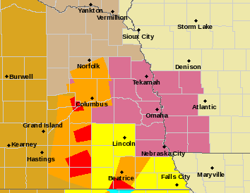
Severe Thunderstorm Watch for counties in mauve color
- Scattered damaging winds and isolated significant gusts to 75 mph likely
- Scattered large hail and isolated very large hail events to 2.5 inches in diameter possible
- A tornado or two possible
SUMMARY…An organizing complex of thunderstorms is expected to pose predominantly a severe-wind threat as it moves eastward through the watch area this evening. Isolated large hail and a tornado also may occur.
The severe thunderstorm watch area is approximately along and 45 statute miles north and south of a line from 15 miles south of Columbus NE to 35 miles north northeast of Shenandoah IA.
PRECAUTIONARY/PREPAREDNESS ACTIONS…
REMEMBER…A Severe Thunderstorm Watch means conditions are favorable for severe thunderstorms in and close to the watch area. Persons in these areas should be on the lookout for threatening weather conditions and listen for later statements and possible warnings. Severe thunderstorms can and occasionally do produce tornadoes.
