


We could get a good soaking of rain this week
October 3rd, 2017 by Ric Hanson
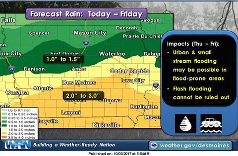
Officials with the National Weather Service in Des Moines this (Tuesday) morning, report that one of the widespread rainiest 7-day forecast periods in quite some time is expected across Iowa this week. Starting today, showers and thunderstorms will move across Iowa from west to east.
We will get a break from the rain on Wednesday, before moderate to heavy rainfall moves in during the day Thursday, lasting overnight into much of Friday. Officials say this time period will likely bring the highest rainfall totals to Iowa during this week, primarily along and south of Interstate 80. Urban and small streams may flood, and flash flooding/river flooding cannot be ruled out at this time.
 Temperatures this week will generally be in the upper 60s to mid 70s. As of now, it appears the middle of next week could bring our first round of true “fall-like” weather, as low temperatures may be in the 30s, with highs struggling to break out of the 50s. There’s a lot of time between now and next week, so stay tuned!

