


Iowa DOT releases 2015-2016 Iowa Transportation Map
June 3rd, 2015 by Ric Hanson
Vacation season is upon us. The Iowa Department of Transportation is encouraging you to take closer look at what our state holds along Iowa’s highways and byways. To help you navigate the State’s extensive transportation system, the Iowa DOT has recently released its 2015-2016 Iowa Transportation Map in the standard fold-out paper form, on the Internet, or through a mobile device viewing app. 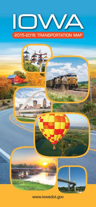
For the first time in recent history with the release of the 2015-2016 map, the agency is producing the publication on a two-year cycle. Mark Hansen, from the Iowa DOT’s Office of Systems Planning, oversees the map production said, “With the popularity of our online map, shifting to a two-year map printing cycle made sense at this time.”
An electronic version of the map, accompanied by an assortment of city detail maps, is also available online at iowadot.gov/maps by selecting the “Iowa Transportation Map” link. Information for a mobile device map viewing app is available there as well. Hansen said, “Because the transportation system is always changing, we do make several hundred changes to the map with each printing. Travelers wanting to keep current with major changes may want to access the online map that is updated annually.”
Transportation is so much more than just highways. The front cover of this year’s map showcases Iowa’s variety of transportation modes, including railroads and trails. The back panel includes a welcome message from Iowa Gov. Terry Branstad and Lt. Gov. Kim Reynolds.
The map shows all highways, airports, rail lines, lakes, rivers, and major county roads. Detail maps are shown for the state’s 16 largest cities that identify highways, major streets, and city boundaries. The map information also includes a chart to find mileage between select Iowa cities; and an index listing the cities shown on the map, along with their populations and map location.
In addition to the standard features mentioned, the map includes two QR codes that can be scanned with a QR reader on a smartphone or other mobile device. Simply download a free QR application from your device’s online app store. One of the codes provides access to all the websites listed on the printed map, as well as a link to the online version of the map. The other provides a direct link to Iowa’s 511 Travel Information website: 511ia.org.
Copies of the 2015-2016 map are available at the Iowa DOT’s 19 driver’s license stations, county treasurer’s offices, all six Iowa DOT district offices, Iowa’s 19 welcome centers, and the state’s rest areas. The map can also be ordered online through the Iowa DOT’s website.
The Iowa Economic Development Authority’s Iowa Tourism Office also distributes maps to all travelers requesting tourism information online and by phone. To order a free Iowa travel packet that includes the new map and Iowa Travel Guide, call 800-345-IOWA (4692) or visit traveliowa.com.
(Press Release)

