Severe Weather forecast for late Tuesday-early Wednesday
June 2nd, 2014 by Ric Hanson
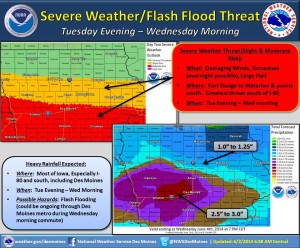
Officials with the National Weather Service say they are forecasting severe weather and flash flooding to become major threats to much of Iowa this upcoming Tuesday evening into Wednesday morning.
The latest forecast from the Storm Prediction Center shows the main threat for severe weather across the U.S. Tuesday will be across Iowa — mainly from Interstate 80 south. Heavy rainfall is expected with these storms. At this point, it shows a more than 45 percent probability of severe weather with the main threats of large hail, tornadoes and widespread damaging winds.
A combination of a much higher than usual amount of available moisture plus very strong wind shear will lead to a strong potential for severe thunderstorms. The storms are likely to move into western Iowa by around midnight, Tuesday. Tornadoes may occur during the overnight hours, so make sure you have a way to receive warning information near your bed before going to sleep.
Several inches of rainfall are also possible by and during the Wednesday morning commute. This could lead to flash flooding in flood-prone areas. Additionally, the Des Moines metro is expected to be impacted by this rainfall, so plan for extra travel time during the Wednesday morning commute.


