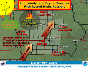
Hot and dry weather in store for the 1st 1/2 of the week
May 13th, 2013 by Ric Hanson
An impressive warming trend remains certain across Iowa today into Tuesday. The warmest day is forecast on Tuesday where near record or record high temperatures are anticipated. Lower to middle 90s for highs will be common over central Iowa. Windy southwest winds and very dry relative humidity will lead to an enhanced fire danger over western and northern Iowa Tuesday afternoon. A cold front will sweep across the state Tuesday night and provide a slight chance of thunderstorms. Cooler temperatures are expected by Wednesday.


