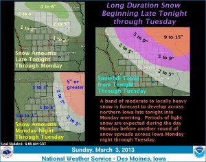
Southwest Iowa should escape threat from latest snowstorm
March 3rd, 2013 by Ric Hanson
Southwest and western Iowa look to have dodged a bullet where the latest snow storm is concerned. The National Weather Services says \aA band of moderate to locally heavy snow is forecast to develop late tonight and continue into Monday morning across northern Iowa before moving northeast into Wisconsin and Minnesota. Periods of light snow are expected from late Monday morning through the afternoon before another round of moderate snow develops Monday evening and continues into Tuesday. North central to northeast Iowa looks to receive the higher snowfall amounts through Tuesday.
A brief period of sleet is possible tonight across southwest Iowa, but little ice accumulation is anticipated. Dry conditions and warmer temperatures are forecast by the late work week.


