More snow expected this weekend, 4-8″ for southern Iowa
March 22nd, 2013 by Ric Hanson
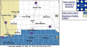
The calendar says it’s spring but winter is most certainly sticking around. Much of Iowa’s southern third is under a Winter Storm Watch for Saturday night into Sunday.
Meteorologist Frank Boksa, at the National Weather Service, says the storm system is heading across the Great Plains and will hit Kansas, Nebraska and Missouri before it starts dumping snow on the Hawkeye State. “The latest computer models are actually bringing the storm a little bit further to the north which would put heavier snow into southern Iowa,” Boksa says. “The exact track of the storm is still uncertain but it does look like southern Iowa could see several inches of snow.”
Forecasts show parts of south-central Iowa may get the deepest snow, with four-to-eight inches possible. Here in the Atlantic area, we may receive anywhere from 1-to 3-inches. Further north, around an inch or less. After the storm passes, Boksa says below-normal temperatures will continue to chill much of the state to start next week, only creeping into the 20s and 30s.
“The normal highs for this time of year are in the low 50s and maybe by this time next week, we’ll be in the mid-40s,” Boksa says. “So we’re not looking, at least in the next week or so, we’re not looking at any big warm-ups.” A year ago, Iowa was enjoying an early spring, with record highs in the 80s.
(Radio Iowa)


